
|
| |||||||||||||||||||

|
Please note that JDLand is no longer being updated.
peek >>
Near Southeast DC Past News Items: mnorth
- Full Neighborhood Development MapThere's a lot more than just the projects listed here. See the complete map of completed, underway, and proposed projects all across the neighborhood.
- What's New This YearA quick look at what's arrived or been announced since the end of the 2018 baseball season.
- Food Options, Now and Coming SoonThere's now plenty of food options in the neighborhood. Click to see what's here, and what's coming.
![-]()
- Anacostia RiverwalkA bridge between Teague and Yards Parks is part of the planned 20-mile Anacostia Riverwalk multi-use trail along the east and west banks of the Anacostia River.
![-]()
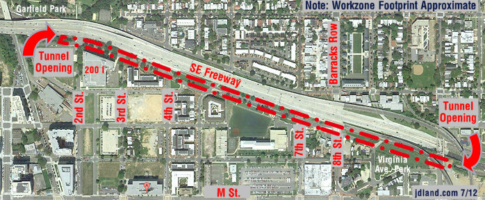
- Virginia Ave. Tunnel ExpansionConstruction underway in 2015 to expand the 106-year-old tunnel to allow for a second track and double-height cars. Expected completion 2018.
![-]()
- Rail and Bus Times
Get real time data for the Navy Yard subway, Circulator, Bikeshare, and bus lines, plus additional transit information. - Rail and Bus Times
Get real time data for the Navy Yard subway, Circulator, Bikeshare, and bus lines, plus additional transit information. - Canal ParkThree-block park on the site of the old Washington Canal. Construction begun in spring 2011, opened Nov. 16, 2012.
![-]()
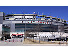
- Nationals Park21-acre site, 41,000-seat ballpark, construction begun May 2006, Opening Day March 30, 2008.
![-]()
- Washington Navy YardHeadquarters of the Naval District Washington, established in 1799.
![-]()
- Yards Park5.5-acre park on the banks of the Anacostia. First phase completed September 2010.
![-]()
- Van Ness Elementary SchoolDC Public School, closed in 2006, but reopening in stages beginning in 2015.
![-]()
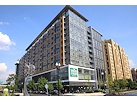
- Agora/Whole Foods336-unit apartment building at 800 New Jersey Ave., SE. Construction begun June 2014, move-ins underway early 2018. Whole Foods expected to open in late 2018.
![-]()
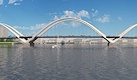
- New Douglass BridgeConstruction underway in early 2018 on the replacement for the current South Capitol Street Bridge. Completion expected in 2021.
![-]()
- 1221 Van290-unit residential building with 26,000 sf retail. Underway late 2015, completed early 2018.
- NAB HQ/AvidianNew headquarters for National Association of Broadcasters, along with a 163-unit condo building. Construction underway early 2017.
- Yards/Parcel O Residential ProjectsThe Bower, a 138-unit condo building by PN Hoffman, and The Guild, a 190-unit rental building by Forest City on the southeast corner of 4th and Tingey. Underway fall 2016, delivery 2018.
- New DC Water HQA wrap-around six-story addition to the existing O Street Pumping Station. Construction underway in 2016, with completion in 2018.
- The Harlow/Square 769N AptsMixed-income rental building with 176 units, including 36 public housing units. Underway early 2017, delivery 2019.
- West Half Residential420-unit project with 65,000 sf retail. Construction underway spring 2017.
![-]()
- Novel South Capitol/2 I St.530ish-unit apartment building in two phases, on old McDonald's site. Construction underway early 2017, completed summer 2019.
![Novel South Capitol]()
- 1250 Half/Envy310 rental units at 1250, 123 condos at Envy, 60,000 square feet of retail. Underway spring 2017.
![-]()
- Parc Riverside Phase II314ish-unit residential building at 1010 Half St., SE, by Toll Bros. Construction underway summer 2017.
![-]()
- 99 M StreetA 224,000-square-foot office building by Skanska for the corner of 1st and M. Underway fall 2015, substantially complete summer 2018. Circa and an unnamed sibling restaurant announced tenants.
![-]()
- The Garrett375-unit rental building at 2nd and I with 13,000 sq ft retail. Construction underway late fall 2017.
![-]()
- Yards/The Estate Apts. and Thompson Hotel270-unit rental building and 227-room Thompson Hotel, with 20,000 sq ft retail total. Construction underway fall 2017.
![-]()
- Meridian on First275-unit residential building, by Paradigm. Construction underway early 2018.
![-]()
- The Maren/71 Potomac264-unit residential building with 12,500 sq ft retail, underway spring 2018. Phase 2 of RiverFront on the Anacostia development.
![-]()
- DC Crossing/Square 696Block bought in 2016 by Tishman Speyer, with plans for 800 apartment units and 44,000 square feet of retail in two phases. Digging underway April 2018.
![DC Crossing]()
- One Hill South Phase 2300ish-unit unnamed sibling building at South Capitol and I. Work underway summer 2018.
![One Hill South Phase 2]()
- New DDOT HQ/250 MNew headquarters for the District Department of Transportation. Underway early 2019.
![New DDOT HQ]()
- 37 L Street Condos11-story, 74-unit condo building west of Half St. Underway early 2019.
![37 L Condos]()
- CSX East Residential/Hotel225ish-unit AC Marriott and two residential buildings planned. Digging underway late summer 2019.
![CSX East Residential/Hotel]()
- 1000 South Capitol Residential224-unit apartment building by Lerner. Underway fall 2019.
![1000 South Capitol Residential]()
- Capper Seniors 2.0Reconstruction of the 160-unit building for low-income seniors that was destroyed by fire in 2018.
![1000 South Capitol Residential]()
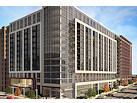
- Chemonics HQNew 285,000-sq-ft office building with 14,000 sq ft of retail. Expected delivery 2021.
![1000 South Capitol Residential]()


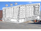


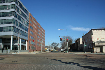
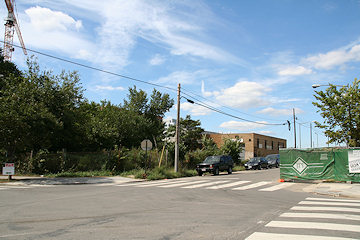 According to the city's land records, on October 7 Akridge paid $4.65 million for the three properties totalling about 7,000 square feet on the south side of K Street between New Jersey and First, all owned by the Cohen family. (Currently on these properties are a defunct garage and an empty lot, as seen in the photo at right). Akridge already owns the lots along First Street south of K down to the Market Deli at L Street; and, from what I can see in my very-unlearned reading of other land records, it also now has agreements with both the Market Deli and the cab garage on the northwest corner of New Jersey and L.
 The only non-Akridge lots left on this block (known as Square 740) are two tiny lots directly behind the Market Deli on L Street and the buildings in the middle of the block along New Jersey where Positive Nature used to operate. (I'll also note, for those for whom this actually means anything, that the Positive Nature lots were the recipients of 52,000 square feet in transferable development rights earlier this year.)
This block is kind of the "last frontier" in the neighborhood, the only one without any sort of large development announced anywhere on it.
|
Comments (0)
More posts:
mnorth, square 740
|
* Monday's Post has a couple of pieces on the state of the area's commercial real estate market, and looks specifically at how NoMa doesn't have tenants racing in despite the high-profile acquisitions of NPR and the Justice Department. It also compares NoMa to Near Southeast, and quotes Russell Hines of Monument Realty as saying that "although the slow economy has made leasing the building more complicated, the company had seen interest from some associations and other private companies looking to escape high rents downtown." Alas, the piece mentions "50 M" as Monument's 275,000-sq-ft office building scheduled for completion next year when it means 55 M. (50 M is Monument's project, too--a proposed 130,000-sq-ft office building on the old Sunoco station site, but they are looking for tenants before starting construction there.)
* A Sunday Examiner piece looks at the temporary zoning rules covering where gun stores can be located in DC: "Firearms dealers who apply for a D.C. location will be largely restricted to high density commercial areas downtown and kept at least two football fields away from where people live, play and pray, according to emergency rules now in place." Included in the allowed zones are C-3-C areas, which means that the area of Near Southeast between South Capitol, Second, M, and the freeway (my "North of M" area) is covered. (See the map on page 8 of the OP report for exact boundaries.) Other restrictions: "All applicants, under the new rules, must appear before the Board of Zoning Adjustments to obtain a special zoning exception. Retail stores will be limited to the downtown area, generally between Massachusetts and Pennsylvania avenues Northwest, in addition to about 25 square blocks between Independence Avenue and M Street in Southwest. No dealer will be allowed within 600 feet of a residence, school, library, church or playground." Of course, the gun stores would have to be able to afford the rents in the pricey new buildings going up, since there aren't too many other places left in the neighborhood.
* Late notice (unless you're subscribed to my Twitter feed, in which case you heard about this yesterday), but there's a Live Online chat today at noon with the author of the Post magazine's piece on the drag queens of Near Southeast, and the man known as "Mame Dennis" who was the focal point of the article will be participating, too.
|
Comments (0)
|
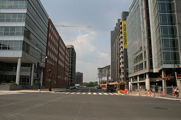
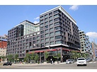
Despite my preference to not ever actually step foot outside in Washington during the summer, I wandered around on Thursday afternoon and got updated photos of 909 New Jersey, Velocity, Onyx, 100 M, and 55 M. I especially enjoy the view that's now developed looking up First Street at M(above), where you see five new buildings in the same vista where 80 M stood all alone less than three years ago.
If you've really got some time to kill today, check the Photo Archive for before-and-afters of these intersections that have changed so much: 1st and I, 1st and K, 1st and L, 1st and M, Half and M, Half and L, Half and K, New Jersey and K, New Jersey and I. Or, just start clicking around on the Archive Map to look at other spots.
Coming soon, photos from a few locations I've never had access to until now....
|
Comments (0)
More posts:
mnorth, Square 743N
|
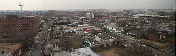

Caught a break with such beautiful weather today, and so I snagged a new batch of overhead photos from up high at the Courtyard by Marriott. I took the entire batch, both east and west, and have paired them with the first ones I took, in March 2006. It's quite a difference; these are the views that people should see when they're carping about "how the area around the ballpark is one big construction zone" -- yes, it is, but look what that construction has done in just two years. (And think of what the commentary would be if this construction *weren't* happening.) You can also toggle to include all the photos from here in 2007 as well, to watch the process step-by-step.
These photos show the progress of 100 M, Onyx, Velocity, 70/100 I, the changes with the Capper Seniors buildings and all the demolitions (and new parking lots!) at Capper. There's even the first views of 909 New Jersey coming up above ground level. I'm still adding some updated photos to those project pages, but you'll get the idea.
|
Comments (0)
More posts:
100 M, 600 M/Square 882/Old Capper Seniors, 70/100 I, 909 New Jersey, Capper, jpi, Courtyard/Marriott, mnorth, Onyx, Square 743N, Square 699n, Velocity Condos
|

When setting out to photograph a changing neighborhood, it might initially seem like a good idea to create a scheme where you take photos of 16 different views at each intersection (from up to four different angles) so that you don't miss anything and so that you can easily match photos as time goes on--until you arrive at a time when there are more than 30 intersections where visible change is happening on a day-to-day basis. Then you end up taking nearly 500 photos in one 90-minute walkabout on a sunny Saturday afternoon (without even venturing near the shiny new ballpark that's only two weeks away from opening), making you almost embarrassed when it's time to post a selection of them on your obsessive-compulsive web site.
This is all just hypothetical, of course.
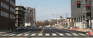
Yesterday was the first time I saw the striped and open-to-traffic First Street north of M, now widened to four lanes with a bike path, and it's kinda different from the First Street I've spent so much time on these past few years. (The four new buildings with one more about to pop up might be part of the feeling, too.) Here's a gallery of before-and-afters for First Street at I, K, L, and M so you can see the changes. This was the first time I've been able to take a complete set of pictures at First and I in nearly a year, so it was especially nice to get those updated.
I also took new photos along Half Street between I and M, Cushing at L and M, and a smattering along M at South Capitol, Van, and New Jersey. And the wide views from the freeway at South Capitol Street. (My previous entry has the links to the photos I took of the various parking lots under construction.) For all of these, don't forget that clicking on the  icon will show you all photos in the archive of that location if you want to see the progression of the changes.
icon will show you all photos in the archive of that location if you want to see the progression of the changes.Of course, many of these new photos are also now on the project pages for the under-construction buildings: see 70/100 I, 909 New Jersey, Velocity, Onyx, 100 M, and 55 M for details.
(There sure were a lot of folks taking either a drive or a walk through the area yesterday--let the onslaught begin! And thanks to those who said hi while I was out and about ["Are you the one who does that web site?"]. As always I appreciate everyone who made the effort to not run me over when I was standing in the middle of the street taking pictures. My days of being able to do that may be at an end, though.)
|
Comments (0)
More posts:
70/100 I, 909 New Jersey, jpi, mnorth, M Street, Onyx, Square 743N, Square 699n, Velocity Condos
|

Let's take a breather from all this parking stuff (which I had my fill of about two years ago) and get back to the original JDLand modus operandi--posting lots of photos of the neighborhood. Yesterday's press conference on the-subject-I-just-said-I-wasn't-going-to-talk-about was held on the 10th floor of 20 M Street, giving me a chance to update my photos from that perch, with views of 70/100 I, Velocity (now working on floor #2), the 1015 Half Street site (where nothing seems to be happening just yet), 55 M, and the ballpark. You can see all photos I've taken from atop 20 M in the past 10 months, or just compare the oldest and newest ones (there's been a few changes!).
Switching to the opposite side of the neighborhood, I took a few shots from Poplar Point on Sunday of the ballpark and The Yards.
You can also see all the new photos (along with the ones taken inside the ballpark looking out at the surrounding neighborhood) on a single page.
I hope to get out this weekend and update the ground-level photos of all the latest happenings.
|
Comments (0)
More posts:
1015 Half, 70/100 I, jpi, mnorth, square 697, Square 699n, Nationals Park, Velocity Condos
|
Sometime within the past few weeks, the surface parking lot at 1100 South Capitol Street has come under the management of Colonial Parking. The spiffy new sign (and the Colonial web site) indicate that it is open for monthly parking only, at a rate of $80 a month. It's on the site where Ruben Companies plans eventually to build its SC1100 office project, but no start date has been announced for that.
As for whether it could possibly be one of the lots that the Nationals are planning to use for season ticket holder parking, I have no information on that, but it's certainly interesting that this lot has suddenly gotten big-time management....
And, in case you didn't see it mentioned in my photo update yesterday, work has begun on the Capper parking lots along Third Street. Some PVC pipes are piled up on the two blocks, and some trench digging is underway at Third and I.
|
Comments (0)
|

It was time this weekend to catch up on photos for a bunch of locations, including the most aged batch of them all, the views of the ballpark's northern footprint along N Street, which haven't been updated since September, so you can now have your fill of photographs of imposing parking garages. The curbs and historic streetlamps are now in, and N Street has been paved from South Capitol to Half, and it looks like the paving east to First isn't far behind. So even though the half-shadow half-sunlight conditions weren't the best to work with, I took full updates of the First, Half, Cushing, and Van intersections along N, all of which you can see here.
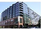
One thing that really struck me today for the first time is just how wide First Street is becoming, as you can see in this batch of northward-looking photos. I also saw that all the businesses on the west side of First south of M have now vacated--as you can see above, it's odd to see those old about-to-be-demolished buildings with sparkly new sidewalks and streetlamps in front of them.
I also trudged around the road construction along First Street north of M as best I could to update photos of 100 M, Onyx, and 70/100 I, and also got a good new batch of 55 M photos as well as the always showy views from the freeway at South Capitol. And I finally got the last set of old Capper Seniors photos to show that the building is indeed gone. And heaven help me I even took a photo of the new sign advertising the Square 696 project, and also a few shots barely showing that work started this week on the first Capper parking lot at Third and I (because there's nothing more exciting than documenting the construction of a parking lot). There's just too much change, and I couldn't stop until it had all been documented! Aaaiiiieeeeee!!!!
For those of you brave enough to try, here's all the photos from the past two days on one page. (Thank heavens I've done a lot of work over the past year or so to automate the update process as much as possible.) Don't forget to click on the icons to see all photos of a location over the years....
icons to see all photos of a location over the years....|
Comments (0)
More posts:
100 M, 1015 Half, 55 M St., 600 M/Square 882/Old Capper Seniors, 70/100 I, The Bixby, Capper, jpi, mnorth, Monument Valley/Half St., Onyx, Square 743N, Square 699n, staddis, Nationals Park, Velocity Condos, Square 701
|
Today's print edition of the Washington Business Journal (online for subscribers only) reports that CNN, wanting 80,000-100,000 sq ft of space to upgrade its studios, is looking at three in-development office buildings in Near Southeast: Opus East's 440,000-sq-ft 1015 Half Street, at the old Nation site, which is scheduled to begin construction in October; Lerner's 320,000-sq-ft 1000 South Capitol right next door, which has no announced start date; and Ruben Companies' 350,000-sq-ft 1100 South Capitol, one block to the south. "Sources familiar with the search say the sites were picked for their views of the Capitol, access to transportation and the opportunity to build a structure designed to fit CNN's needs instead of retrofitting an existing building." It should be noted that WBJ also wrote back in late March that CNN (and other companies) were looking at Near Southeast.
|
More posts:
1000 South Capitol, 1015 Half, 1100 South Capitol, Development News, mnorth, officespace, square 697, square 698
|
Tucked in the stories (Post and WashTimes) about the bill that passed its first reading in front of the council yesterday--allowing the relocation of the strip clubs that have left Near Southeast because of the arrival of the stadium and surrounding development--was word that an amendment to the bill had passed allowing clubs to relocate to certain zoned areas within 5,000 feet of the ballpark. People are already e-mailing me with the vapors, so here's what I've been able to find out.
The circle covered by a one-mile radius around the stadium site stretches across all of Near Southeast, most of Buzzards Point, a fair amount of Southwest, and even into Anacostia and small portions of Capitol Hill. But the text of the amendment says that the clubs can relocate "in any C-3, C-4, or C-5 zone within 5000 feet from the Baseball Stadium footprint"; once you take into account those restrictions, when you look at the zoning maps you'll see that there are very few locations that have those zone designations; in Near Southeast, the only areas meeting that criteria are the land bounded by South Capitol, I, M, and New Jersey (what I call the "North of M" area) and the area just south the freeway over to the Post Plant. In Southwest, the area between I, M, South Capitol, and 2nd St. SW, and the Waterside Mall parcel, are the only C-3/4/5 zones within the 5,000-foot radius. And across the river in Anacostia there is only one small area zoned C-3-A.
But, given the character of the areas in Near Southeast where these one-time strip club relocations would be allowed, it would appear to be a remote possibility--after all, what the clubs generally look for are large spaces with low rents, and with most C-3 parcels in Near Southeast now purchased by developers with grand plans for shiny new buildings, it would seem that the large-space/low-rent options east of South Capitol are few and far between. Unless the club owners decide to build big tents beneath the freeway.
|
|