|
| ||||||||||||||||||||
Please note that JDLand is no longer being updated.
peek >>
Near Southeast DC Past News Items: officespace
- Full Neighborhood Development MapThere's a lot more than just the projects listed here. See the complete map of completed, underway, and proposed projects all across the neighborhood.
- What's New This YearA quick look at what's arrived or been announced since the end of the 2018 baseball season.
- Food Options, Now and Coming SoonThere's now plenty of food options in the neighborhood. Click to see what's here, and what's coming.
- Anacostia RiverwalkA bridge between Teague and Yards Parks is part of the planned 20-mile Anacostia Riverwalk multi-use trail along the east and west banks of the Anacostia River.
- Virginia Ave. Tunnel ExpansionConstruction underway in 2015 to expand the 106-year-old tunnel to allow for a second track and double-height cars. Expected completion 2018.
- Rail and Bus Times
Get real time data for the Navy Yard subway, Circulator, Bikeshare, and bus lines, plus additional transit information. - Rail and Bus Times
Get real time data for the Navy Yard subway, Circulator, Bikeshare, and bus lines, plus additional transit information. - Canal ParkThree-block park on the site of the old Washington Canal. Construction begun in spring 2011, opened Nov. 16, 2012.
- Nationals Park21-acre site, 41,000-seat ballpark, construction begun May 2006, Opening Day March 30, 2008.
- Washington Navy YardHeadquarters of the Naval District Washington, established in 1799.
- Yards Park5.5-acre park on the banks of the Anacostia. First phase completed September 2010.
- Van Ness Elementary SchoolDC Public School, closed in 2006, but reopening in stages beginning in 2015.
- Agora/Whole Foods336-unit apartment building at 800 New Jersey Ave., SE. Construction begun June 2014, move-ins underway early 2018. Whole Foods expected to open in late 2018.
- New Douglass BridgeConstruction underway in early 2018 on the replacement for the current South Capitol Street Bridge. Completion expected in 2021.
- 1221 Van290-unit residential building with 26,000 sf retail. Underway late 2015, completed early 2018.

- NAB HQ/AvidianNew headquarters for National Association of Broadcasters, along with a 163-unit condo building. Construction underway early 2017.

- Yards/Parcel O Residential ProjectsThe Bower, a 138-unit condo building by PN Hoffman, and The Guild, a 190-unit rental building by Forest City on the southeast corner of 4th and Tingey. Underway fall 2016, delivery 2018.

- New DC Water HQA wrap-around six-story addition to the existing O Street Pumping Station. Construction underway in 2016, with completion in 2018.

- The Harlow/Square 769N AptsMixed-income rental building with 176 units, including 36 public housing units. Underway early 2017, delivery 2019.

- West Half Residential420-unit project with 65,000 sf retail. Construction underway spring 2017.
- Novel South Capitol/2 I St.530ish-unit apartment building in two phases, on old McDonald's site. Construction underway early 2017, completed summer 2019.
- 1250 Half/Envy310 rental units at 1250, 123 condos at Envy, 60,000 square feet of retail. Underway spring 2017.
- Parc Riverside Phase II314ish-unit residential building at 1010 Half St., SE, by Toll Bros. Construction underway summer 2017.
- 99 M StreetA 224,000-square-foot office building by Skanska for the corner of 1st and M. Underway fall 2015, substantially complete summer 2018. Circa and an unnamed sibling restaurant announced tenants.
- The Garrett375-unit rental building at 2nd and I with 13,000 sq ft retail. Construction underway late fall 2017.
- Yards/The Estate Apts. and Thompson Hotel270-unit rental building and 227-room Thompson Hotel, with 20,000 sq ft retail total. Construction underway fall 2017.
- Meridian on First275-unit residential building, by Paradigm. Construction underway early 2018.
- The Maren/71 Potomac264-unit residential building with 12,500 sq ft retail, underway spring 2018. Phase 2 of RiverFront on the Anacostia development.
- DC Crossing/Square 696Block bought in 2016 by Tishman Speyer, with plans for 800 apartment units and 44,000 square feet of retail in two phases. Digging underway April 2018.
- One Hill South Phase 2300ish-unit unnamed sibling building at South Capitol and I. Work underway summer 2018.
- New DDOT HQ/250 MNew headquarters for the District Department of Transportation. Underway early 2019.
- 37 L Street Condos11-story, 74-unit condo building west of Half St. Underway early 2019.
- CSX East Residential/Hotel225ish-unit AC Marriott and two residential buildings planned. Digging underway late summer 2019.
- 1000 South Capitol Residential224-unit apartment building by Lerner. Underway fall 2019.
- Capper Seniors 2.0Reconstruction of the 160-unit building for low-income seniors that was destroyed by fire in 2018.
- Chemonics HQNew 285,000-sq-ft office building with 14,000 sq ft of retail. Expected delivery 2021.
 While wandering around the web site for the city's Department of Real Estate Services, I found out that the deadline has been extended until noon tomorrow for the request for offers to lease data center space at the revamped 225 Virginia Avenue (aka the old Star/Post Plant). They've also posted a Q&A about the RFO that may or may not hold any nuggets of interest.
But what broke my heart is the last sentence of a press release from mid-July touting the financing deal that's allowing construction to begin on the project late this year:
"In related news, the address for 225 Virginia Avenue, SE will change. The new address will be 200 I Street, SE."
Waaaaaaahhhhh! It will always be 225 Virginia to me!
But, looking at the rendering of the redesign, it appears that they're moving the main entrance to the south side of the building, facing Canal Park, hence the I Street designation.
|
Comments (0)
More posts:
225 Virginia/Old Post Plant/200 I, Development News, officespace
|
 Multiple anonymous sources are allowing CityBiz Real Estate to report: "Corporate Office Properties Trust is awaiting lender approval on a $120 million acquisition of Maritime Plaza, a 12-acre site located at the East End of the Washington, D.C. Naval Yard, multiple sources tell citybiz real estate." This follows a story earlier today saying that COPT was close to purchasing an unnamed site, described only as being a fully leased location occupied primarily by defense contractors.
 If this goes through, it would be the third time the site has changed hands since construction on the second office building was completed in 2003, with Bernstein Cos. selling it for $92 million in 2004, and then Brickman Associates reportedly paying $115 million in October of 2005. The site, which has two completed office buildings, has included plans for two additional 175,000-square-foot office buildings and a 250-room hotel; leasing is handled by Lincoln Property Company. The land beneath the buildings and plans, however, continues to be owned by Washington Gas, as it has been since pretty much the dawn of time.
|
Comments (0)
|
 WBJ updates its story from a few months ago to basically say, yes, DDOT is still planning to move to 55 M Street, Monument Realty's building on top of the west entrance of the Navy Yard station. The city council has until close of business today (Wednesday) to decide if it wants to hold up the plans, and apparently the council's budget office is taking a close look at the lease, since it will cost DDOT about $6.9 million per year over 10 years to consolidate all of its workers in Near Southeast, compared to the $3.1 million it's paying now to lease space in multiple buildings.
With USDOT just two blocks to the east, M Street SE would turn into Transportation Row if DDOT does indeed come to 55 M.
|
Comments (0)
|
 The city's Department of Real Estate Services (formerly OPM) has put out a solicitation to sublease 50,750 square feet of below-grade space at 225 Virginia Avenue as a data center. While that may be terribly interesting to some people, probably the item of greater interest is the rendering on the first page, which is the first glimpse of the "reskinned" building, showing the current gray windowless monolith rebuilt into a more open structure that actually resembles an office building. The rendering is from the building's southwest corner, so the SE Freeway (not shown) would run "behind" the building. You can just barely see Capitol Quarter townhouses at far right, making that Third Street.
The solicitation also says that construction is expected to begin in November of this year and last 15 months, with development being handled by StonebridgeCarras while the city continues to own the land. When completed, three city agencies will occupy the building--the Commission on Arts and Humanities, the Office of the Chief Technology Officer [hence the data center stuff], and the Child and Family Services Agency. If you see people wandering around the site on Tuesday, it's a site tour for parties interested in the data center colocation. Responses to the solicitation are due to the city on July 30.
If you're just joining the story now, feel free to read my past 225 Virginia posts to catch up on the many twists and turns this building has seen over the past few years. (h/t DCMud)
|
Comments (0)
More posts:
225 Virginia/Old Post Plant/200 I, Development News, officespace
|
 Oh, I've wanted to post this rumor for so long (and have hinted at it on Twitter) but never could bring myself to pull the trigger when I couldn't get anything out of Monument or DDOT or any first-level source. But, here's WBJ going where I wouldn't (subscribers only): "[The District Department of Transportation] has signed a letter of intent and is close to a deal on a 10-year lease for 150,000 square feet in Monument Realty's Half Street building at 55 M St. SE, according to sources." Neither Monument nor DDOT would confirm to WBJ either, with DDOT spokesman John LIsle quoted as saying, "We are hoping to move this year. It may be ambitious, but that is our goal."
Originally DDOT was going to move to the Anacostia Gateway project, but that was cancelled a few months ago. WBJ says that, between DDOT's space and existing tenant Sayres and Associates (who apparently will be adding another 10,000 square feet to their lease), 55 M will be about two-thirds leased.
|
Comments (0)
|
 Thanks to one of the National Capital Planning Commission's fabulous documents, we're starting to get first hints of plans by the Cohen Companies for what they are describing as a three-building, 815,000-square-foot office, hotel, retail project on the very eastern end of M Street, nestled between Boathouse Row and the CSX tracks east of Maritime Plaza. It's so early in the process that it's not even on Cohen's New Projects page, but City Paper's Housing Complex blog has learned that the company will be putting together a planned unit development application to the Zoning Commission "over the next six to nine months." (No financing is lined up, though, so don't look for digging to start anytime soon.) See the NCPC document for some early drawings and some basic information on how they envision the offerings of the three buildings.
(Cohen Companies, by the way, is the developer of Velocity.)
Back in 2003-ish, there were plans for this site to be a townhouse development (see page 15), but those never got off the ground partly because of zoning issues, which then begat an attempted rezoning of the area in 2004 that failed. But rezoning of the site will have to be back in the forefront when this project's PUD application hits the zoning committee, since the space is still zoned "M" (industrial).
The project is in front of NCPC because of Cohen's request to close "paper street" segments of Virginia Avenue, M, and 14th streets. This is a part of a settlement between 1333 M Street, SE, LLC and the city from a lawsuit over waterfront development in South*west*, where the Cohen Companies are agreeing to release their claims in exchange for three small pieces of government land at 1333 M SE as well as the city's support in requesting the street closures. (The street closures themselves have been approved by the city council as bill B18-0572, and are expected to become law later this month.)
The NCPC is objecting to the street closures; and thankfully Greater Greater Washington has been writing in detail on the case, so I'm just going to throw it over to them for all the nitty gritty, because it's way out of my league. (Read also this GGW entry about connecting this area to the neighborhoods to its north if/when the remnants of the freeway to Barney Circle are removed.) But, again, the NCPC staff recommendation report is also a great read for not only the NCPC's concerns but also for the history of the area under review and other details. The NCPC board is meeting this afternoon, and we'll see what comes out of the session (I assume GGW will be hot on the trail).
If you've never ventured down that way, my East M page has a few not-particularly-current photos of the location (I don't get there very often myself), along with more images of Boathouse Row. When the project begins to wind its way through the zoning process, I'll get more on the ball. The city's 2009 Boathouse Row Planning Study is also a good spot to learn more about the area.
UPDATE: Thanks to commenter Evan, I'm reminded that I should have included the additional information that, because this is part of the old Washington Gas (and I think Steuart Petroleum) site, there are some serious remediation issues to be addressed, which are mentioned both by Ron Cohen on page 25 of this 2003 ZC transcript and on page 19 of this 2004 ZC transcript (saying that the contaminated soil is 11 feet down). Remediation is also mentioned in the 2009 Boathouse Row Planning Study and in this EPA document (under "Washington Gas and Light"). Oh, and the EPA's 1999 record of decision on what cleanup remedies would be needed. It should be noted that both Maritime Plaza buildings were completed after this document. (This is all before my time, so I'm researching on the fly.)
UPDATE II: Here's a WBJ article (subscribers only for 7 days) on the NCPC angle; it also reminds that, outside the monumental core of the city, NCPC's rulings are purely advisory.
|
Comments (0)
|
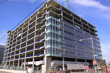
 We went through this back in early March, when sharp-eyed JDLand readers passed along indications of work re-starting at the stalled 1015 Half Street office building project, with a Skanska sign going up at the skeleton. But it disappeared soon afterward, along with the workers that had briefly materialized. But last Tuesday, faithful Tweeters again reported signs of life at the work site, and now WBJ is reporting that Skanska USA Building is indeed about to re-start construction, expecting to finish the 440,000-sq-ft office and retail project by the end of the year.
This building, on the site of the old Nation nightclub, was first started in late 2007 before the collapse of developer Opus East ground work to a halt in May 2009. (These photos show the timeline pretty well!) The Douglas Wilson Companies was named receiver a few months later, and originally announced that work would re-commence in October of last year, but nothing has happened until now.
No tenants have been announced. See my 1015 Half page for more details on the long and winding road this project has taken.
UPDATE: Here's the press release from DWC announcing the restart.
|
Comments (0)
|
Some alert readers reported today via e-mail and Twitter that there is renewed activity at the site of 1015 Half Street, where construction of the 440,000-sq-ft office building was halted in the middle of 2009 when owner Opus East went bust and liquidated. (The Douglas Wilson Companies was named receiver for the property in August.) I've heard no official announcements, but the many liens against the property were settled in January, and apparently people are on-site, and a new fence and "Skanska" sign are now up at Half and L, so we'll see if the project is in fact moving again.
|
Comments (0)
|
I'm hearing that the Douglas Wilson Companies--a San Diego developer specializing in "distressed properties and crisis management" that was appointed in late July as receiver for both 1015 Half Street and 100 M--is getting construction moving again at 1015 Half (along with "aggressively" marketing and leasing of the building). Also, a "disposition strategy" for 100 M is expected to be in place later this month. This appears to be Wilson's first foray into the DC market, though the company also has branches in Atlanta, Las Vegas, Miami, Orlando, and San Francisco. This San Diego Business Journal profile of Wilson and his company gives a bit more info not only on the organization but on the role of a receiver in dealing with distressed properties. The two buildings hit the skids when Opus East collapsed and liquidated.
UPDATE: Here's the press release.
|
Comments (0)
|
Opus East, the development company whose portfolio includes the already completed 100 M and under construction 1015 Half office buildings, filed on Wednesday for Chapter 7 liquidation, according to the Washington Business Journal. The article mentions the falling through of Opus's deal to sell 100 M to MayfieldGentry Realty Advisors earlier this year as part of the company's woes, and the building is part of the bankruptcy filing and liquidation. The 1015 Half Street project, expected to finish late this year or early next year, is presumably part of it as well. No tenants for the 440,000-sq-ft office building have been announced.
|
Comments (0)
|


