
|
| |||||||||||||||||||

|
Please note that JDLand is no longer being updated.
peek >>
Near Southeast DC Past News Items
- Full Neighborhood Development MapThere's a lot more than just the projects listed here. See the complete map of completed, underway, and proposed projects all across the neighborhood.
- What's New This YearA quick look at what's arrived or been announced since the end of the 2018 baseball season.
- Food Options, Now and Coming SoonThere's now plenty of food options in the neighborhood. Click to see what's here, and what's coming.
![-]()
- Anacostia RiverwalkA bridge between Teague and Yards Parks is part of the planned 20-mile Anacostia Riverwalk multi-use trail along the east and west banks of the Anacostia River.
![-]()
- Virginia Ave. Tunnel ExpansionConstruction underway in 2015 to expand the 106-year-old tunnel to allow for a second track and double-height cars. Expected completion 2018.
![-]()
- Rail and Bus Times
Get real time data for the Navy Yard subway, Circulator, Bikeshare, and bus lines, plus additional transit information. - Rail and Bus Times
Get real time data for the Navy Yard subway, Circulator, Bikeshare, and bus lines, plus additional transit information. - Canal ParkThree-block park on the site of the old Washington Canal. Construction begun in spring 2011, opened Nov. 16, 2012.
![-]()
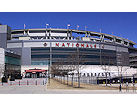
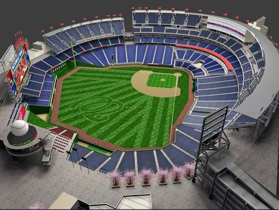
- Nationals Park21-acre site, 41,000-seat ballpark, construction begun May 2006, Opening Day March 30, 2008.
![-]()
- Washington Navy YardHeadquarters of the Naval District Washington, established in 1799.
![-]()
- Yards Park5.5-acre park on the banks of the Anacostia. First phase completed September 2010.
![-]()
- Van Ness Elementary SchoolDC Public School, closed in 2006, but reopening in stages beginning in 2015.
![-]()
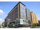
- Agora/Whole Foods336-unit apartment building at 800 New Jersey Ave., SE. Construction begun June 2014, move-ins underway early 2018. Whole Foods expected to open in late 2018.
![-]()
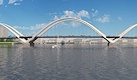
- New Douglass BridgeConstruction underway in early 2018 on the replacement for the current South Capitol Street Bridge. Completion expected in 2021.
![-]()
- 1221 Van290-unit residential building with 26,000 sf retail. Underway late 2015, completed early 2018.
- NAB HQ/AvidianNew headquarters for National Association of Broadcasters, along with a 163-unit condo building. Construction underway early 2017.
- Yards/Parcel O Residential ProjectsThe Bower, a 138-unit condo building by PN Hoffman, and The Guild, a 190-unit rental building by Forest City on the southeast corner of 4th and Tingey. Underway fall 2016, delivery 2018.
- New DC Water HQA wrap-around six-story addition to the existing O Street Pumping Station. Construction underway in 2016, with completion in 2018.
- The Harlow/Square 769N AptsMixed-income rental building with 176 units, including 36 public housing units. Underway early 2017, delivery 2019.
- West Half Residential420-unit project with 65,000 sf retail. Construction underway spring 2017.
![-]()
- Novel South Capitol/2 I St.530ish-unit apartment building in two phases, on old McDonald's site. Construction underway early 2017, completed summer 2019.
![Novel South Capitol]()
- 1250 Half/Envy310 rental units at 1250, 123 condos at Envy, 60,000 square feet of retail. Underway spring 2017.
![-]()
- Parc Riverside Phase II314ish-unit residential building at 1010 Half St., SE, by Toll Bros. Construction underway summer 2017.
![-]()
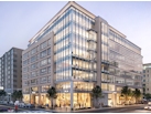
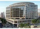
- 99 M StreetA 224,000-square-foot office building by Skanska for the corner of 1st and M. Underway fall 2015, substantially complete summer 2018. Circa and an unnamed sibling restaurant announced tenants.
![-]()
- The Garrett375-unit rental building at 2nd and I with 13,000 sq ft retail. Construction underway late fall 2017.
![-]()
- Yards/The Estate Apts. and Thompson Hotel270-unit rental building and 227-room Thompson Hotel, with 20,000 sq ft retail total. Construction underway fall 2017.
![-]()
- Meridian on First275-unit residential building, by Paradigm. Construction underway early 2018.
![-]()
- The Maren/71 Potomac264-unit residential building with 12,500 sq ft retail, underway spring 2018. Phase 2 of RiverFront on the Anacostia development.
![-]()
- DC Crossing/Square 696Block bought in 2016 by Tishman Speyer, with plans for 800 apartment units and 44,000 square feet of retail in two phases. Digging underway April 2018.
![DC Crossing]()
- One Hill South Phase 2300ish-unit unnamed sibling building at South Capitol and I. Work underway summer 2018.
![One Hill South Phase 2]()
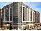
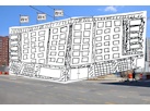
- New DDOT HQ/250 MNew headquarters for the District Department of Transportation. Underway early 2019.
![New DDOT HQ]()
- 37 L Street Condos11-story, 74-unit condo building west of Half St. Underway early 2019.
![37 L Condos]()
- CSX East Residential/Hotel225ish-unit AC Marriott and two residential buildings planned. Digging underway late summer 2019.
![CSX East Residential/Hotel]()
- 1000 South Capitol Residential224-unit apartment building by Lerner. Underway fall 2019.
![1000 South Capitol Residential]()
- Capper Seniors 2.0Reconstruction of the 160-unit building for low-income seniors that was destroyed by fire in 2018.
![1000 South Capitol Residential]()
- Chemonics HQNew 285,000-sq-ft office building with 14,000 sq ft of retail. Expected delivery 2021.
![1000 South Capitol Residential]()


1070 Blog Posts Since 2003
Go to Page: 1 | ... 9 | 10 | 11 | 12 | 13 | 14 | 15 | 16 | 17 ... 107
Search JDLand Blog Posts by Date or Category
Go to Page: 1 | ... 9 | 10 | 11 | 12 | 13 | 14 | 15 | 16 | 17 ... 107
Search JDLand Blog Posts by Date or Category
With the area in the stadium corridor between South Capitol and First streets apparently in need of significant upgrades to its water and sewer infrastructure, the city council is working on a bill that would create a special assessment to fund the $15.45 million needed for the improvements. It was decided to take care of these upgrades now because the streets that the pipes lie under--South Capitol, Potomac, First, N, and I--are scheduled to be reconstructed in the coming months as part of the streetscape improvement project before the Nationals ballpark opens, and it was thought best to take care of the sewer work now rather than having to dig up newly renovated streets. Landowners (including the city and the U.S. government) would be assessed based on total land area and the gross building area as allowed by zoning for each parcel of land that abuts or benefits from the improvements, and would be able to pay their assessment either in an up-front lump sum or over time. With the city contributing $3 million toward the project up front and another $4.1 million to cover the assessments on public properties, the other landowners will end up funding $8.35 million of the project cost.
The bill was marked up on July 13, and apparently has changed somewhat, but you can read the original version of the legislation here. When the committee report is finalized and the revised bill is available, I'll post them as well.
It should be noted that the water and sewer improvements for the stadium itself have already been taken care of, and similar improvements for The Yards and Capper/Carrollsburg will be handled through their PILOT funding programs.
|
|
Steve Eldridge, in his traffic column in the Examiner today, reports he has heard very few complaints from readers related to the Douglass Bridge closure and its spillover effects. "It seems like the city did a very good job at planning ahead for this event including the decision to do the work during the summer months, when traffic volumes are at their lows for the year. [...] I know that we give the District a hard time in this space, but this project seems to be something that has been well thought out and well executed ... at least so far." Dr. Gridlock in the Post wrote a lot about it in his Get There blog early last week, but hasn't covered it for a few days.
|
More posts:
Douglass Bridge, Traffic Issues
|
 I hit the pavement this morning (before it began to melt a few hours later), and have posted a pile of new photos in the Stadium Exterior Construction Gallery, the additional north/south/east/west stadium views for the fanatics, and the Douglass Bridge Extreme Makeover page, which in particular has more new stunning before-and-afters of the South Capitol Street/Potomac Avenue intersection.
|
More posts:
Douglass Bridge, Nationals Park
|
It's been rumored for ages, and even as of a few days ago I couldn't get confirmation, but reader Dave says we now have a "Starbucks Coming Soon" sign in the window of the little glassed-in annex on the DOT headquarters's northwestern corner, at New Jersey and M. I don't know when they plan on opening. But, fear not, pricey hot caffeinated beverages will be in your grasp before too long!
|
More posts:
US Dept. of Transportation HQ, Retail
|
Who could envision a more exciting Friday night than watching the Tivo'ed coverage of today's DC Council Committee on Economic Development Public Hearing on the plans for the transition of the Anacostia Waterfront Corporation and the National Capital Revitalization Corporation into the office of the Deputy Mayor for Planning and Economic Development. (Maybe it's time for a new JDLand motto: We bore ourselves to tears so you don't have to.)
What is probably the biggest headline from the hearing for those with Near Southeast interests is that Deputy Mayor Neil Albert called "totally incorrect" the recent reports that construction would begin on Canal Park in August. Valerie Santos Young, now the Chief Operating Officer of the Deputy Mayor's office, said that negotiations are continuing with both the owner of the unused parking lot of the northernmost block of the park (Urban Parking Ventures) and with the group that owns the lease for the school bus parking on the other two blocks, but no agreements have been reached.
With that pleasant news out of the way, there really wasn't much else of note in the hearing that specifically impacts Near Southeast. There will be job cuts as the three organizations are merged into one, and employees should know their status in the new plan by Aug. 15; the number of positions being cut wasn't disclosed. They are planning to expand the DMPED office space in the Wilson Building, but will also be renewing the lease on the AWC offices at 1100 New Jersey Ave. for additional space. (They are working to break the lease for the old NCRC office space on M Street.) Accenture is being paid $320,000 for three months to help with the transition (which got some questioning from Kwame Brown as to why a local firm couldn't have been hired for the job). No documents on the reorganization were given to the committee before the hearing, which Brown wasn't too thrilled about, but Albert says that the new organization chart will be ready by August.
And, as much as I tried to close my ears to any non-Near Southeast discussions, I did hear that the city is not planning to sign the Memorandum of Understanding that the AWC had negotiated with the Southwest Waterfront redevelopment team, because the city's lawyers were concerned about possible exposure (which wasn't elaborated on). Albert said that they feel that an agreement can be reached that covers everything in the MOU without actually having an MOU.
There were also conversations about the management of the marinas, which baffled me until I realized everyone was saying "live-aboards" and not "liverboards."
You can catch a rebroadcast of the hearing on Saturday at 12:30 pm on either DC Cable 13 or via streaming video. If you subscribe to the Washington Business Journal, today's print edition had a short pre-hearing piece on the transition plans.
There will be additional oversight hearings in September and October, and Kwame Brown indicated that he plans to have additional hearings on every development project now in the DMPED portfolio, to make sure that the public is kept abreast of the plans and the timelines.
|
|
A press release just in over the transom is announcing that Forest City has hired CB Richard Ellis to handle the leasing of what's being called 401 M Street, the office building to be built on the southeast corner of 4th and M just east of the US Department of Transporation HQ. This is "Parcel D" on my Yards First Phase page, and is the building that will have a grocery store on the first floor in addition to the 300,000 sq ft of office space. Construction is scheduled to start next year, with delivery in spring 2010. (There's also an ad announcing this in today's print edition of the Washington Business Journal.)
|
|
They're not really that exciting to look at, but I now have a few photos from yesterday evening showing that the ground floor of the Onyx on First condo project has sprouted. (Its sibling 100 M Street, coming out of the same hole, is on a slower schedule, it appears.)
And with the Douglass Bridge viaduct now gone, I've started making some additions and deletions to my Stadium Exterior Construction Gallery to change out the photos I had been taking from up on the viaduct and replacing them with some new angles. And there will probably be more changes to come, especially with the western parking garage at South Capitol and N now clearly visible. If you scroll through the stadium page, you'll be rewarded about halfway down with a photo showing the first panes of glass installed on the southwest side of the ballpark. And I'll be doing my usual photo update on Sunday for the other three sides of stadium.
|
More posts:
Onyx, Nationals Park
|
 On this gorgeous late afternoon (which would have been PERFECT for a Topping Out ceremony!), I got back down to the Douglass Bridge demolition for the first time in a few days, and whether it was the deep blue sky or the new camera lens or what, I snagged some pretty striking photos of the changed landscape on South Capitol Street between N and Potomac. I've posted them on my Douglass Bridge Extreme Makeover page, of course--I also added some more stitched-together panoramas of what the intersections looked like before. All the new shots today are from the west side--access to the east side of South Capitol is far more limited thanks to the stadium, so shots looking westward from anywhere other than Potomac Ave. may just have to wait until the work is all done. I'm going to be working on getting more photos of these intersections into the Photo Archive; but I've been just a wee bit busy over these past few days (!) and so haven't had the chance.
Speaking of the work, there was nothing left of the old viaduct on my visit other than the pile of dirt that used to make up the earth-fill ramp between O and P streets (well, there's whole lot of rubble, too). So we can say that the demolition took six days. Now we get to watch for the lowering of the northernmost remaining portion of the bridge, the building of the new earth-fill ramp up from Potomac Ave. to meet the existing bridge, and the streetscaping of the rest of South Capitol. And we get to see just how quickly the contractor can pull this off ahead of the eight-week schedule. (Up to $1 million in incentives are being dangled in front of them.)
Getting it done quick will certainly ease the burden of thousands of commuters, who are really taking it on the chin with this project. Today there's a number of stories about Metro ticketing the folks who are parking illegally in the lots on the east side of the Anacostia. Channel 9, Channel 7, Channel 4, WTOP, and the Post's Marc Fisher all weigh in. And the Southern Maryland Gazette writes about the traffic problems from an outside-the-Beltway perspective.
|
More posts:
South Capitol St.
|
This afternoon, the National Capital Planning Commission gave their "does not adversely effect federal interests" approval to the recent zoning amendment allowing temporary surface parking lots on various blocks near the stadium, subject to the removal of the Canal Park parcels from the amendment and also that any of the temporary lots on waterfront parcels be set back a minimum of 75 feet from the Anacostia shoreline. They also want the final order of the text amendment to make clear that the five-year cap on these lots cannot be extended via a Board of Zoning Adjustment Special Exception.
The staff report indicated what we've heard in the last day or so, that the Office of Planning will indeed be modifying the amendment to take out Reservation 17 parcels B, C, and D (the Canal Park blocks) before the Zoning Commission's final vote on July 30. There was also slightly curt exchange between two of the commissioners during the discussion of the parking situation about why the US Department of Transporation headquarters can't make some accommodation to allow public parking (as the Reagan building does) in some of its 800 parking spaces; as is now so often the case in this city, "Sept. 11" was the answer.
The commission also approved the 35% design plans for The Yards--many of the renderings and drawings that were in the presentation to the board today are already on my Yards First Phase page. This submittal to the NCPC covered the streetscape, landscape, and infrastructure improvement plans, and the plans for the first four developments on the site--renovation of two existing buildings to create 430 residential units, the renovation of Building 167 into a 46,000-sq-ft retail space, and the construction of two new buildings at 4th and M that would have 320,000 sq ft of office space, a grocery store, and 170+ apartments. Work on the streetscape and infrastructure improvements will be starting this summer, and the first of the building renovations will get underway next year, with 170 apartments and the Building 167 retail to be delivered in mid-2009. This plan will also be in front of the Commission on Fine Arts on July 19.
I hope to get electronic versions soon of the staff recommendation documents for both of these votes, which contain lots of good summary information for people who haven't been following these cases quite as, um, closely as SOME people. I'll update here when I get them.
So, for Canal Park fans, everything seems to be pointing to the hoped-for conclusion, though it won't be 100% written in stone until the July 30 Zoning Commission meeting.
UPDATE: Here's the recommendation document for The Yards; I hope to have the parking one on Friday, so check back.
UPDATE II: Believe it or not, NBC 4 covered the meeting today. (Maybe they got the idea from today's District Extra!)
UPDATE, 7/13: Here's the recommendation document for the parking zoning amendment.
|
|
At Tuesday's council meeting, an emergency resolution was passed to allow the issuance of bonds that will bring $140 million in proceeds to fund various Anacostia waterfront projects, including the waterfront park at The Yards and Diamond Teague Park. The money is coming from a Payment-in-Lieu-of-Taxes agreement for the Department of Transportation HQ, land that can't be taxed by the city because it's federal property. The original PILOT bill laying out the specifics was passed last October and the city and DOT developer JBG signed the agreement in February. I'm not 100% sure why there's now this new emergency resolution, although my bleary-eyed morning reading of it sees that perhaps the council was required to officially approve which projects were designated to get the funding. And, in order to issue the bonds before the end of this fiscal year, the council needed to act quickly, hence the emergency legislation.
A tidbit from the resolution: one of the projects listed as needing this funding is "a new ferry pier at the foot of First Street, SE"; this is the Diamond Teague Park location that's right across the street from the ballpark. I've been hearing rumors lately that the Anacostia Waterfront Corporation has the building of this pier on a very fast track, with the intention of getting it ready by Opening Day 2008; there's scuttlebutt is that the permit applications have already been filed with the US Army Corps of Engineers, though I don't see evidence of that just yet. Perhaps we'll hear more about this at tomorrow's hearing on the move of the AWC into the Office of the Deputy Mayor for Planning and Economic Development.
|
|
My Ballpark and Beyond column in The Post's District Extra today covers the Canal Park parking lot brouhaha. If you're arriving here looking for more background, here's the zoning amendment that started it all, last night's news that the Office of Planning looks firmly committed to rectifying the oversight, my page with details on all the plans for stadium parking around Near Southeast, today's NCPC meeting agenda, and my Canal Park page for details on the plans for the park itself. I'll be posting later today on the outcome of the NCPC meeting.
|
More posts:
Canal Park, zoning
|
In advance of Thursday's National Capital Planning Commission meeting that will review the surface parking lots zoning amendment, the Voice of the Hill has posted a piece about the controversial inclusion of the Canal Park blocks within the parcels approved for parking. Much of the piece covers territory I've written about over the past few days, but has some new nuggets. Money quote: "Joel Lawson, the Office of Planning's acting deputy director for neighborhood and long-range planning, said the portions of squares containing Canal Park were never intended to be used for parking and should not have been included. 'I can understand why people are concerned about this,' he said. But, he added, 'We knew the parking wasn't going to go there.' He said the planning office will amend its request to make explicit this provision." Another quote, from the spokesman for Deputy Mayor of Planning and Economic Development Neil Albert: "We have no intention to use this three-block site for stadium parking, and we fully expect to move forward in building this important public amenity on schedule." This would appear to make the NCPC meeting less of a critical juncture, but I'll still be there to check it out. Besides, they're also having a big presentation on the first-phase plans for The Yards.
|
|
On July 18, the Metropolitan Police Department is holding a Community Meeting on the Relocation of MPD to the old Post Plant site at 225 Virginia Ave.; Tommy Wells will be in attendance as well. Word is already going around about the meeting to residents of Southwest, who are not happy that these proposed relocation plans include the move of the First District police station from Southwest over to Southeast. I imagine parking questions will also be part of the discussion. The meeting is at St. Mark's Episcopal Church, 3rd and A Streets, SE, at 6:30 pm on the 18th.
|
More posts:
225 Virginia/Old Post Plant/200 I
|
As soon as I dry off (which might take until 2008), I'll post pictures from today's rain out of a Topping Out celebration. Keep checking back.
UPDATE: Here are my photos from the Topping Out. No prize-winners in the bunch, but I'm lucky at this point that my camera didn't fill up with water. If you're really wanting to see what the interior of the stadium looks like on a sunny day, here are some shots of it from 10 days ago. Enjoy.
UPDATE II: And now the media pieces begin to flow on the ceremony. Here's WTOP's, to start. And yes, it's on time and on budget.
UPDATE III: MLB.com.
UPDATE IV: Washington Post. Channel 4. Channel 7. Channel 9. Associated Press. And, to go backwards a bit, Channel 5's piece on the topping out from before the ceremony. And, last ones, the WashTimes and the Examiner.
|
More posts:
Nationals Park
|
The demolition of the beams from the old Douglass Bridge viaduct along South Capitol Street north of Potomac continues apace today, and you can really "watch" it over the next few hours on Camera #2 of the Stadium Construction Webcam, which updates every 20 minutes or so. Just keep hitting the "View Most Recent Image" box under the calendar (and zoom in for a better view). I'm betting they'll be finished with the beams by the end of the day or tomorrow, and will have only the earth fill approach ramp north of P left. Then there'll be the cleanup and the work to create the new roadway over the next few weeks, but that won't be anywhere near as much fun to check out on the webcam as the demolition is..... (Plenty of other work will be happening out of the webcam's view, of course, such as the lowering of the portion of the bridge just north of the Anacostia shoreline and the building of the new ramp down to Potomac Ave.) And note that the concrete pillars you see in the ground in front of the bridge demolition are for the "knife-edge" Nationals office building that will be attached to the stadium. You can see the concrete already starting to be poured for the south point of the building. And the line of steel beams in front of the admin building construction are for the sloped promenade that will come from Potomac Avenue up to the stadium.
We do need to offer them a hankie to clean the lens, though!
UPDATE. 5:15 pm: The girders are now all gone--all that's left of the viaduct is the brick-lined ramp between O and P, and it won't last much longer, either. As fun as it is to sneak peeks of it on the webcam, I had hoped to have new photos of my own today--but the deluge during the stadium topping out dampened my enthusiasm for further picture taking. More pics soon, I promise.
|
|
 If you want to know what the views of the field will be from any section in the new Nationals ballpark, you can use this pretty cool interactive seating chart -- click on a section, and a window will pop up that displays renderings of the stadium from that vantage point. (The overhead view of the stadium's bowl is pretty nice, so I've added it to my stadium renderings page, too.) Nats ticketholders and fans have already been playing with this for a while, but even if you're not in either of those categories, it's a neat little app to check out.
The ballpark "Topping Out" party is today; I should have some photos from it posted later this afternoon.
|
More posts:
Nationals Park
|
They haven't officially announced its launch, but I happened to wander by this evening and found that the Velocity Condos official web site is now live. It's got a sign-up form if you're interested in this 200-unit building at 1st and L, and a long list of the planned amenities, but no drawings of the building (you can see one of those along with more details on my own Velocity Condos page). The new site also says that sales center (at Half and K) will be opening soon, and it will have a "detailed scale model" and a "furnished model home right in the sales center." Digging has just gotten underway, and delivery is expected in 2009.
|
More posts:
Square 699n, Velocity Condos
|
The US Navy Museum has released its July/August schedule of events, which I've added to my Upcoming Events calendar. So take the Little Skippers down to the museum for some maritime craft-making!
|
More posts:
Navy Yard
|
The city council has approved today the creation of the Capitol Riverfront Business Improvement District, covering all of Near Southeast as well as much of Buzzards Point in SW. They enacted not only the permanent legislation but also an emergency bill allowing the BID to be created immediately, rather than waiting for the permanent legislation to wind its way through Congress. (Check out my previous BID entries for more background on what a BID is.) Welcome to the neighborhood, BIDders....
|
More posts:
Capitol Riverfront BID
|
Removal of the steel girders along the old northern approach of the Douglass Bridge viaduct continues today, and that work has now come into view when looking at Camera #2 of the Nationals Stadium Construction Cam, starting with the 12:32 pm image. (And, for the fun of it, check out the 2:27 and 2:41 images for the Noah's Ark view of the site.) Dr. Gridlock's blog has another entry today about the traffic fallout from the bridge's closure. And of course my Douglass Bridge Extreme Makeover page has my photos of the site, with more to come tomorrow. UPDATE: Another Dr. Gridlock post discusses the now-overflowing state of the Anacostia Metro station parking lot.
|
|
1070 Posts:
Go to Page: 1 | ... 9 | 10 | 11 | 12 | 13 | 14 | 15 | 16 | 17 ... 107
Search JDLand Blog Posts by Date or Category
Go to Page: 1 | ... 9 | 10 | 11 | 12 | 13 | 14 | 15 | 16 | 17 ... 107
Search JDLand Blog Posts by Date or Category