
|
| |||||||||||||||||||

|
Please note that JDLand is no longer being updated.
JDLand.com Search Results for eis
- Full Neighborhood Development MapThere's a lot more than just the projects listed here. See the complete map of completed, underway, and proposed projects all across the neighborhood.
- What's New This YearA quick look at what's arrived or been announced since the end of the 2018 baseball season.
- Food Options, Now and Coming SoonThere's now plenty of food options in the neighborhood. Click to see what's here, and what's coming.
![-]()
- Anacostia RiverwalkA bridge between Teague and Yards Parks is part of the planned 20-mile Anacostia Riverwalk multi-use trail along the east and west banks of the Anacostia River.
![-]()
- Virginia Ave. Tunnel ExpansionConstruction underway in 2015 to expand the 106-year-old tunnel to allow for a second track and double-height cars. Expected completion 2018.
![-]()
- Rail and Bus Times
Get real time data for the Navy Yard subway, Circulator, Bikeshare, and bus lines, plus additional transit information. - Rail and Bus Times
Get real time data for the Navy Yard subway, Circulator, Bikeshare, and bus lines, plus additional transit information. - Canal ParkThree-block park on the site of the old Washington Canal. Construction begun in spring 2011, opened Nov. 16, 2012.
![-]()
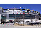
- Nationals Park21-acre site, 41,000-seat ballpark, construction begun May 2006, Opening Day March 30, 2008.
![-]()
- Washington Navy YardHeadquarters of the Naval District Washington, established in 1799.
![-]()
- Yards Park5.5-acre park on the banks of the Anacostia. First phase completed September 2010.
![-]()
- Van Ness Elementary SchoolDC Public School, closed in 2006, but reopening in stages beginning in 2015.
![-]()
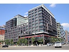
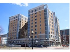
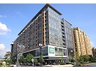
- Agora/Whole Foods336-unit apartment building at 800 New Jersey Ave., SE. Construction begun June 2014, move-ins underway early 2018. Whole Foods expected to open in late 2018.
![-]()
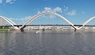
- New Douglass BridgeConstruction underway in early 2018 on the replacement for the current South Capitol Street Bridge. Completion expected in 2021.
![-]()
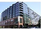
- 1221 Van290-unit residential building with 26,000 sf retail. Underway late 2015, completed early 2018.
- NAB HQ/AvidianNew headquarters for National Association of Broadcasters, along with a 163-unit condo building. Construction underway early 2017.
- Yards/Parcel O Residential ProjectsThe Bower, a 138-unit condo building by PN Hoffman, and The Guild, a 190-unit rental building by Forest City on the southeast corner of 4th and Tingey. Underway fall 2016, delivery 2018.
- New DC Water HQA wrap-around six-story addition to the existing O Street Pumping Station. Construction underway in 2016, with completion in 2018.
- The Harlow/Square 769N AptsMixed-income rental building with 176 units, including 36 public housing units. Underway early 2017, delivery 2019.
- West Half Residential420-unit project with 65,000 sf retail. Construction underway spring 2017.
![-]()
- Novel South Capitol/2 I St.530ish-unit apartment building in two phases, on old McDonald's site. Construction underway early 2017, completed summer 2019.
![Novel South Capitol]()
- 1250 Half/Envy310 rental units at 1250, 123 condos at Envy, 60,000 square feet of retail. Underway spring 2017.
![-]()
- Parc Riverside Phase II314ish-unit residential building at 1010 Half St., SE, by Toll Bros. Construction underway summer 2017.
![-]()
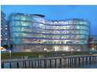
- 99 M StreetA 224,000-square-foot office building by Skanska for the corner of 1st and M. Underway fall 2015, substantially complete summer 2018. Circa and an unnamed sibling restaurant announced tenants.
![-]()
- The Garrett375-unit rental building at 2nd and I with 13,000 sq ft retail. Construction underway late fall 2017.
![-]()
- Yards/The Estate Apts. and Thompson Hotel270-unit rental building and 227-room Thompson Hotel, with 20,000 sq ft retail total. Construction underway fall 2017.
![-]()
- Meridian on First275-unit residential building, by Paradigm. Construction underway early 2018.
![-]()
- The Maren/71 Potomac264-unit residential building with 12,500 sq ft retail, underway spring 2018. Phase 2 of RiverFront on the Anacostia development.
![-]()
- DC Crossing/Square 696Block bought in 2016 by Tishman Speyer, with plans for 800 apartment units and 44,000 square feet of retail in two phases. Digging underway April 2018.
![DC Crossing]()
- One Hill South Phase 2300ish-unit unnamed sibling building at South Capitol and I. Work underway summer 2018.
![One Hill South Phase 2]()
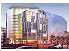
- New DDOT HQ/250 MNew headquarters for the District Department of Transportation. Underway early 2019.
![New DDOT HQ]()
- 37 L Street Condos11-story, 74-unit condo building west of Half St. Underway early 2019.
![37 L Condos]()
- CSX East Residential/Hotel225ish-unit AC Marriott and two residential buildings planned. Digging underway late summer 2019.
![CSX East Residential/Hotel]()
- 1000 South Capitol Residential224-unit apartment building by Lerner. Underway fall 2019.
![1000 South Capitol Residential]()
- Capper Seniors 2.0Reconstruction of the 160-unit building for low-income seniors that was destroyed by fire in 2018.
![1000 South Capitol Residential]()
- Chemonics HQNew 285,000-sq-ft office building with 14,000 sq ft of retail. Expected delivery 2021.
![1000 South Capitol Residential]()


Search term: eis (southcap) : 34 matching blog entries
Tuesday Tidbits: Declaration, Barracks, Road Work, Willow V-Day
Feb 6, 2018 10:53 AM
A few of these deserve their own posts, but, well....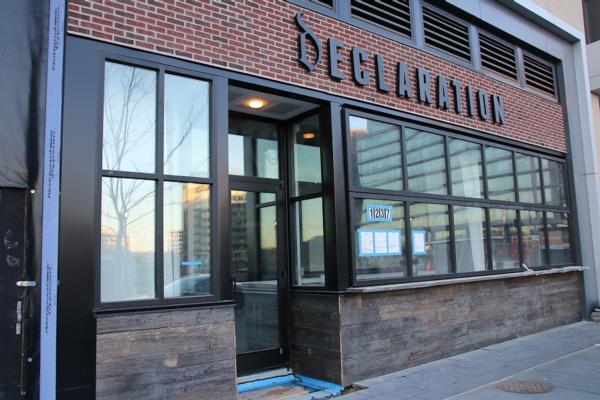 * DECLARATION DECLARING: A press release from Grosvenor says that Declaration will be opening at F1rst, in mid-March, as the building's first full-service dining option. "This new location will be double the size of its counterpart in [Shaw] and will offer pizza and Philadelphia-oriented menu items, including some ballpark staples." The release also says that Barre3 will open in
 spring late summer or fall [error in press release, I'm told]. With these openings, only one retail space at F1rst remains unleased.
 I have been intending to write more substantively about a few of these things, but now in the interest of actually getting them posted, I'll go with abbreviated versions:
 * DECLARATION DECLARING: A press release from Grosvenor says that Declaration will be opening at F1rst, in mid-March, as the building's first full-service dining option. "This new location will be double the size of its counterpart in [Shaw] and will offer pizza and Philadelphia-oriented menu items, including some ballpark staples." The release also says that Barre3 will open in
 * BARRACKS DECIDING: The Record of Decision and Final EIS for the new Bachelor Enlisted Quarters have been published, ending a study phase that feels like it began in 1936. The chosen site plan is to build the new BEQ immediately to the north of the barracks at 7th and L, SE (Building 25), which will spell doom for either some or all of the athletic field (it's been so long, I don't remember anymore). Read the MBEIS web site for actual details that aren't from memory.
* SOUTH CAPITOL PROJECTING: DDOT announced some temporary lane closures this week in multiple locations "for pre-construction work associated with the South Capitol Street Corridor Project and the new Frederick Douglass Memorial Bridge project." I believe this is the first mention of "pre-construction work" for these projects--or at least they are since the design-build contract was awarded.
* PEPCO DISRUPTING: ANC 6D07 Commissioner Fascett reports that PEPCO will be digging up portions M Street SE between 1st and 6th and 1st south of M to install underground pipes and then cables during February and March. Watch for daytime traffic disruptions weekdays and Saturdays.
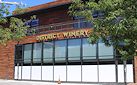
* WILLOW VALENTINING: If you are in a red-heart mood on Saturday (Feb. 10), retail boutique Willow is having a Valentine's Day party, from 11 am to 7 pm. There will be valentine-making, cupcakes, a photo booth, and more. (Strangely, the valentines give out all look like this.) Willow is in the ground floor of Arris, on Water Street across from District Winery, just north of the Yards Park.
Comments (2)
More posts:
Barracks, declaration, F1rst Residential/Hotel, Restaurants/Nightlife, Retail, Douglass Bridge, Traffic Issues, willow
Tuesday Tidbits: Short and Sweet
Nov 14, 2017 11:49 AM
 I have been intending to write more substantively about a few of these things, but now in the interest of actually getting them posted, I'll go with abbreviated versions:
* DOUGLASS BRIDGE MEETING: DDOT is holding two public meetings to "discuss the current status" of the new Douglass Bridge project. There is one in Ward 6 on Tuesday, Nov. 28 from 6:30 to 8:30 pm at 1100 4th St., SW (DCRA conference room), and another in Ward 8 on Wednesday, Nov. 29 from 6:30 to 8:30 pm at the Thurgood Marshall Academy, 2427 Martin Luther King Jr. Ave., SE. See my project page and/or the official web site for details.
* DOUGLASS BRIDGE BLEATING: The Commission on Fine Arts says the new bridge design "lacks grace." (WBJ)
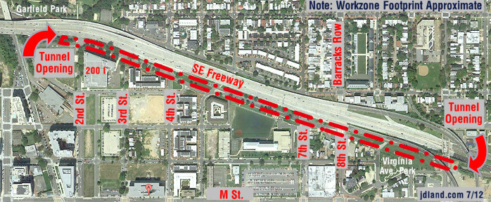
* 3RD STREET TWEAKING: Watch for the single travel lane on 3rd Street SE at Virginia Avenue to be moved off of the temporary deck and onto new pavement Any Minute Now. This is so the deck can be demolished and restoration work can then continue on both 3rd and Virginia. (CSX)
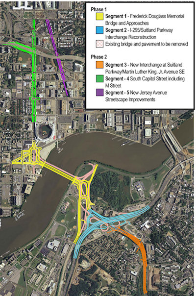 More than two years after four teams were shortlisted for the opportunity to compete for the project, DDOT announced today that it has issued the final Request for Proposals (RFP) for the first phase of the South Capitol Street Corridor reconstruction, which includes a new Douglass Bridge and approach work, plus a new interchange at I-295 and the Suitland Parkway.
* BARRACKS EIS RELEASING: Remember those plans to build a new Marine Bachelor Enlisted Quarters, which ended up deciding that the new building would be built next to the existing building at 7th and L? There's actually some movement, with the final EIS expected to be released Any Minute Now, and the Record of Decision expected to follow. I'll write more when the EIS comes out, but in the meantime here's a newsletter from last month with the latest.
* ANC REP REPPING: Read more updates on neighborhood goings-on from ANC 6D07 commissioner Meredith Fascett.
* TASTEBUDS APPROVING: Ana, the restaurant at District Winery, gets good words from the Post's food critic. (WaPo)
Comments (11)
New Douglass Bridge Update: Final RFP Issued
Mar 30, 2016 1:29 PM
 More than two years after four teams were shortlisted for the opportunity to compete for the project, DDOT announced today that it has issued the final Request for Proposals (RFP) for the first phase of the South Capitol Street Corridor reconstruction, which includes a new Douglass Bridge and approach work, plus a new interchange at I-295 and the Suitland Parkway.
The release today says that design/build proposals from the four teams are due this fall, and that DDOT expects to begin construction in the spring of 2017, and complete this first phase in 2020, but, well, We Shall See.
I absolutely cannot bear to write about this in any detail AGAIN, so if you haven't been keeping up with the plans to replace the existing 67-year-old bridge, please check out my post from August 2015, when it was announced that the project got its federal approval/record of decision, or my post from late 2014 about the supplemental EIS that presented some tweaks to the plan that had been stalled after a preferred alternative was identified back in 2011.
But if clicking on one of those links is more than you yourself can bear, I will just plagiarize the summary I wrote in August:
As you can see in the pilfered-from-DDOT graphic above, the new bridge will run immediately parallel and downriver of the existing bridge, with two new large traffic ovals on its approaches. There will also be a much-needed reconstruction of the I-295/Suitland Parkway interchange.
The bridge will have three travel lanes in each direction, along with 18-feet-wide pedestrian/bike paths on both the up-river and down-river edges of the bridge, which will be configured as one 8-foot-wide lane for pedestrians and a 10-foot-wide bidirectional bike path.
The process to build a new Douglass Bridge hasn't exactly been moving at lightning speed, but nevertheless an important milestone has been reached: on August 14 it was announced that "the Federal Highway Administration (FHWA) approved the Supplemental Final Environmental Impact Statement (SFEIS) and issued a Record of Decision (ROD) for the South Capitol Street Corridor Project—both indicating federal approval of the project."
The eventual second phase of this overall "South Capitol Street Corridor Project" will be streetscape improvements to the north end of the street, similar to the spiffening that the blocks from N to Potomac received back in 2007 that give the street more of an "urban boulevard" feel. This will include a full redesign of the M Street intersection and a reconfiguration of South Capitol's interchange with I-395.
My South Capitol Street and South Capitol Street Bridge project pages are also good places to go for details.
Comments (9)
More posts:
South Capitol St., Douglass Bridge, Traffic Issues
New Douglass Bridge Gets Federal OK, $587M Funding from DC
Aug 31, 2015 2:19 PM
The process to build a new Douglass Bridge hasn't exactly been moving at lightning speed, but nevertheless an important milestone has been reached: on August 14 it was announced that "the Federal Highway Administration (FHWA) approved the Supplemental Final Environmental Impact Statement (SFEIS) and issued a Record of Decision (ROD) for the South Capitol Street Corridor Project—both indicating federal approval of the project."And with $587 million in DC's budget already earmarked for the project, DDOT can move forward with the next big step: choosing the design-build team, presumably from among the "final four" bidders identified back in February 2014, a process that is scheduled to be completed by the end of 2016.
The current Douglass Bridge is now 66 years old, and has been classified as "functionally obsolete." DDOT says that if it is not replaced "within the next five years, the bridge would require an estimated $110 million in major rehabilitation work and would need to be closed for more than a year."
(And, maybe I'm just getting older and turning into even more of a fraidy cat, but holy moly is the traffic making the current bridge vibrate like crazy when you walk the pedestrian path. I just don't remember it moving that much even six months ago. Which perhaps might explain this bit of crumbling I saw on Saturday.)
This is now at least my 120th post on the bridge and the plans to replace it, so I'll go with a very quick summary (this post from last December is a good catch-up option). As you can see in the pilfered-from-DDOT graphic above, the new bridge will run immediately parallel and downriver of the existing bridge, with two new large traffic ovals on its approaches. There will also be a much-needed reconstruction of the I-295/Suitland Parkway interchange.The bridge will have three travel lanes in each direction, along with 18-feet-wide pedestrian/bike paths on both the up-river and down-river edges of the bridge, which will be configured as one 8-foot-wide lane for pedestrians and a 10-foot-wide bidirectional bike path.
The eventual second phase of this overall "South Capitol Street Corridor Project" will be streetscape improvements to the north end of the street, similar to the spiffening that the blocks from N to Potomac received back in 2007 that give the street more of an "urban boulevard" feel. This will include a full redesign of the M Street intersection and a reconfiguration of South Capitol's interchange with I-395. The full Request for Proposals is expected to be released in the spring of 2016.
 If you are looking for some light Christmas reading, you can sit down by the fireplace with all 335 pages (plus appendices!) of the newest revision to the plans for reconfiguring much of South Capitol Street, including the construction of a new Frederick Douglass Bridge.
 The full Request for Proposals is expected to be released in the spring of 2016.
While waiting for the new bridge to arrive, I may have to put out calls for volunteers willing to let me tether myself to them when I need to take pictures from the existing bridge, because otherwise the authorities will probably have to respond to calls of an old lady frozen in place on the pedestrian path, holding a camera but too terrified to move.
Comments (8)
More posts:
South Capitol St., Douglass Bridge
Latest South Capitol Corridor Draft Plan Released; Meeting Jan. 22
Dec 22, 2014 2:33 PM
 If you are looking for some light Christmas reading, you can sit down by the fireplace with all 335 pages (plus appendices!) of the newest revision to the plans for reconfiguring much of South Capitol Street, including the construction of a new Frederick Douglass Bridge.
This document, technically known as the Supplemental Draft Environmental Impact Statement (SDEIS), describes the new "revised preferred alternative" (RPA) design that tweaks the original preferred alternative in the Final EIS released back in 2011.
The bullet points for what the project plans are north/west of the Anacostia River are in the graphic at right (click to enlarge). The changes in this new RPA include:
* Changing the design of the bridge from a moveable span to a fixed-span bridge, which would save approximately $140 million in construction costs;
* Shifting the orientation of the new Douglass Bridge to an alignment parallel to the existing bridge, 30 feet down river, which avoids the need and lengthy process to acquire some land from Joint Base Anacostia-Bolling as well as a number of expensive relocation and reconstruction issues that a new alignment avoids (see page 2-91 of the SDEIS for details);
* A slight reduction of the size of the traffic oval on the western side (at Potomac Avenue):
* Replacing the previously designed circle on the eastern approach with an oval, located entirely in the DDOT right-of-way;
* And several other changes on the east side of the project that I will leave to others to discuss in detail. (See page ES-6 of the SDEIS.)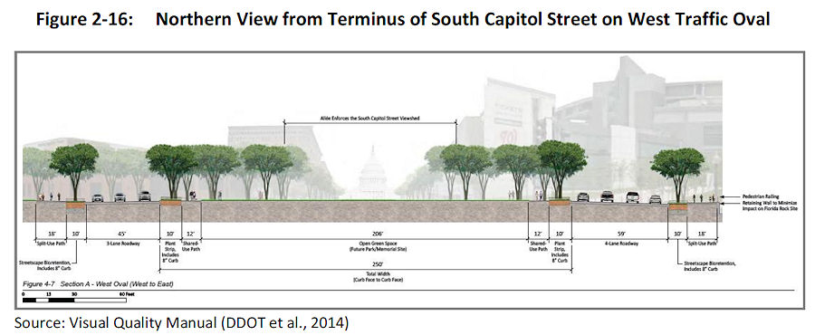 The initial design of the ovals and of the bridge itself were met with some consternation during this revision process. The SDEIS notes that in response to these concerns, DDOT has created a "Visual Quality Manual" for the project, which identifies design goals that are to "reflect the vision of providing a grand urban boulevard, which will be a gateway into the nation's capital, an iconic symbol of the District's aspirations in the 21st century, and a catalyst to revitalize local neighborhoods and the Anacostia Waterfront." (page 2-26).
 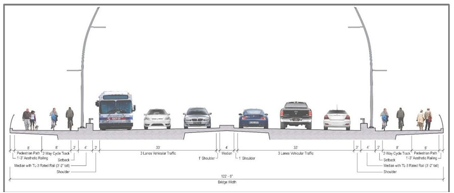 As for the bridge itself, the version in this RPA will support three travel lanes in each direction, along with 18 feet of bicycle and pedestrian paths on *both* sides of the bridge--an 8-foot lane for pedestrians and a 10-foot birdirectional bike path. (Enlarge the image at right to see that I'm not lying about the bike/ped stuff.)
 The initial design of the ovals and of the bridge itself were met with some consternation during this revision process. The SDEIS notes that in response to these concerns, DDOT has created a "Visual Quality Manual" for the project, which identifies design goals that are to "reflect the vision of providing a grand urban boulevard, which will be a gateway into the nation's capital, an iconic symbol of the District's aspirations in the 21st century, and a catalyst to revitalize local neighborhoods and the Anacostia Waterfront." (page 2-26).
  As for the bridge itself, the version in this RPA will support three travel lanes in each direction, along with 18 feet of bicycle and pedestrian paths on *both* sides of the bridge--an 8-foot lane for pedestrians and a 10-foot birdirectional bike path. (Enlarge the image at right to see that I'm not lying about the bike/ped stuff.)
And the design of the bridge is to "make its primary aesthetic impact through its position (alignment), and the shape and sizes of its structural elements" and is to " aesthetically appear to be part of a continuous urban corridor." This includes the avoidance of "using elements, solely for aesthetic effect, which do not contribute to the support of the bridge." (page 2-28)
Plans for the reconfiguration of South Capitol Street as a "grand urban boulevard" have all along called for changing the intersection of South Capitol and M streets to an "at-grade intersection" (page 4-79), which would also mean that K and L would have signalized four-way intersections with South Capitol, unlike today. The wide median seen south of N would be established on the north end of the street as well, now all the way to D Street SE in the RPA. Also changing in this new plan are a few new left-turn options at I Street SE/SW and L Street SE. Revisions have also been made to the ramps from South Capitol Street to I-395 and I-695, but the basics from the original plans remain, most notably the demolition of the existing suspended ramp from northbound South Capitol to the SE/SW Freeway.
 Revisions have also been made to the ramps from South Capitol Street to I-395 and I-695, but the basics from the original plans remain, most notably the demolition of the existing suspended ramp from northbound South Capitol to the SE/SW Freeway.
Even with the revisions made to cut the costs of the new Douglass Bridge, this isn't a cheap project. The five phases together are anticipated to cost over $1 billion, with Segment 1, including the new bridge and traffic ovals, estimated at $480 million. The "grand boulevard"-izing of South Capitol Street is estimated at $153 million, and planned streetscape improvements to New Jersey Avenue between D and M streets SE at $42 million, plus another $358 million in east-of-the-river improvements (page 2-11).
 Last week DDOT announced the four teams that have been chosen to advance to the next round and battle it out for the grand prize of being able to design and build the new Douglass Bridge and its approaches as well as reconstruct the Suitland Parkway/I-295 interchange, a prize package worth at least $608 million.
Worn out yet? I sure am! (I've mostly lost track of how much of this is truly even "new" news at this point.) But perhaps you can regain your strength by Jan. 22, 2015, when the public meeting on this SDEIS will be held from 6:30 to 8:30 pm at Matthews Memorial Baptist Church Fellowship Hall, 2616 Martin Luther King Ave., SE. The public comment period is running until Feb. 2. DDOT is also still amidst the design/build proposal process, with proposals expected sometime in the spring.
The SouthCapitolEIS.com web site is now focused mainly on this SDEIS, of which clearly I've just scratched the surface; you can slog through my piles of posts on all of this over the years for the historical rundown.
UPDATE: Here's the WashCycle take on the latest plans, from a bike/ped perspective.
Comments (5)
More posts:
Pedestrian/Cycling Issues, meetings, M Street, South Capitol St., Douglass Bridge, Traffic Issues
Short List Picked for Douglass Bridge Rebuild
Feb 2, 2014 11:21 AM
 Last week DDOT announced the four teams that have been chosen to advance to the next round and battle it out for the grand prize of being able to design and build the new Douglass Bridge and its approaches as well as reconstruct the Suitland Parkway/I-295 interchange, a prize package worth at least $608 million.
 These four teams will now have the opportunity to respond to DDOT's Request for Proposals on the project, which should be released at some point in the not-too-distant future.
The two reconstruction projects are officially known as Segments 1 and 2 in the two-phase/five-part South Capitol Street Corridor Project, which will also eventually extend the "grand boulevard" feel from a reconfigured M Street intersection north to the Southeast Freeway, build a new on-ramp there, and throw in some streetscape enhancements along New Jersey Avenue as well.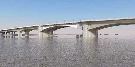 I missed out on a fair amount of discussion of this project last year, including the mayor "announcing the new design" of the bridge that was only marginally different than the design that's been on the boards for a number of years (though the announcement did include a cool video). The announcement was followed by some controversy over the size and necessity of the traffic ovals and even the bridge design itself. (But some cyclists seem okay with it.)
I missed out on a fair amount of discussion of this project last year, including the mayor "announcing the new design" of the bridge that was only marginally different than the design that's been on the boards for a number of years (though the announcement did include a cool video). The announcement was followed by some controversy over the size and necessity of the traffic ovals and even the bridge design itself. (But some cyclists seem okay with it.)I also didn't get the chance to note that the position of the bridge has undergone some alteration, in that the new bridge's footprint is now designed to run completely parallel to the current bridge, instead of a more diagonal alignment from the original EIS, which you can see compared on pages 11 and 12 of this October 2013 project update.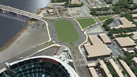 In the fall, both the National Capital Planning Commission and the Commission of Fine Arts looked at the project, with the latter pooh-poohing the "uninspired" bridge design and calling for a the design-build process to come up with a "more innovative proposal" instead of the Memorial Bridge-like arched bascule design that DDOT has chosen. Both commissions are generally supportive of the two ovals, though NCPC's comments after a November review of the project notes that more discussions of the western oval (just southwest of Nationals Park) "will need to occur to help further the ideas of creating a vibrant destination."
In the fall, both the National Capital Planning Commission and the Commission of Fine Arts looked at the project, with the latter pooh-poohing the "uninspired" bridge design and calling for a the design-build process to come up with a "more innovative proposal" instead of the Memorial Bridge-like arched bascule design that DDOT has chosen. Both commissions are generally supportive of the two ovals, though NCPC's comments after a November review of the project notes that more discussions of the western oval (just southwest of Nationals Park) "will need to occur to help further the ideas of creating a vibrant destination."While waiting for the RFP to be released and for the designs of the bridge and the ovals to be "refined" for NCPC/CFA approval, you can check out my Douglass Bridge project page, my South Capitol Street page, and the reams of words I've written about both over the years.
Comments (2)
More posts:
South Capitol St., Douglass Bridge
Land Acquisition, Design Work to Start for South Capitol Street
Sep 28, 2011 2:51 PM
Just sent out by DDOT: "Today the District Department of Transportation (DDOT) announced the start of land acquisition and preliminary design work for the South Capitol Street Project, which includes replacement of the current Frederick Douglass Memorial Bridge. [...] While the Record of Decision (ROD) is still pending, the Federal Highway Administration signed the project's Final Environmental Impact Statement (FEIS) following the requisite 30-day public comment period that ended in May."
I'm posting quickly, so I shall now crib unabashedly from my post on the Final EIS, from back in April:
If you are interested in this subject, there is more verbiage and documentation accompanying the plans than you could ever dream of. (Traffic studies! Environmental consequences! Technical reports!) And I've written a lot about the process, which began more than a decade ago with other studies before the EIS got underway. And I'm sure there will be posts on other blogs delving more specifically into portions of the plans. But, since most people probably want to know "what does this mean for me?", you can see this graphic (from the 224-MB chapter 2 of the FEIS) giving a quick overview of what changes are planned along South Capitol Street if the final EIS is signed off on (and, more importantly, if funding is secured). The short version, for the west side of the Anacostia:
 eisprefalt.jpg" width=180>* Add "pedestrian amenities" and enhance the streetcape along South Capitol north of I and along New Jersey Avenue SE north of the freeway.
 eisprefalt.jpg" width=180>* Add "pedestrian amenities" and enhance the streetcape along South Capitol north of I and along New Jersey Avenue SE north of the freeway.
* Replace the existing ramp to the freeway from South Capitol and I with an at-grade intersection. (This would be a left turn onto a ramp to the freeway from under the freeway, near the current Nats HH economy parking lot.)
* Bring New Jersey Avenue SE back to a 160-foot full right-of-way, and add streetscape enhancements.
* "Reconstruct South Capitol Street as an urban boulevard." This means bringing M Street up to an "at-grade" intersection (no more tunnel), and would include new signalized at-grade intersections to allow traffic to cross South Capitol on K and L streets. (M Street would also get reconstructed between the Halfs [SE and SW].) The section of South Capitol north of M would have the same streetscape that the south portion received during its 2007/08 makeover, with wide sidewalks and a tree-lined median.
* Build a traffic oval at South Capitol, Potomac, Q, as the gateway to a new arched bascule-design Douglass Bridge that would have wide "multi-use trails" (i.e., sidewalks!) in both directions. The existing bridge would be demolished, after the new bridge is built somewhat downriver of the current location.
The Executive Summary (220 MB PDF) gives a good overview of the FEIS and preferred alternative (as it should!), but I also suggest wandering through the Chapter 2: Alternatives section, especially if you came to the neighborhood or JDLand after 2008 and didn't get to follow along during the EIS process, or if you're interested in the additional plans for east of the river, which I'm going to leave to others to discuss. My previous posts on all of this may be of interest as well. If you're wanting to see some of the earlier studies referenced in the FEIS, there are links to them at the top of my South Capitol Street project page.
How much would this all cost? The preferred alternative is priced in this final EIS at $806 million in FY 2014 dollars. (New bridges are expensive, you know.) Note that nothing in today's statement from DDOT says anything about funding, or a construction timeline.
You can also check my South Capitol Street and South Capitol Street Bridge page for all the info about the plans, along with my scores of posts over the past few years.
Comments (6)
More posts:
South Capitol St., Douglass Bridge, Traffic Issues
Tuesday Tidbits: South Cap Meetings, Barracks, Sub Horn, More
Apr 26, 2011 10:42 AM
News and notes, some already Tweeted, some not:
* Don't forget the two public meetings on the Final Environmental Impact Statement for South Capitol Street. The first one is tonight (April 26) at Amidon-Bowen Elementary School at 4th and I, SW, from 6:30 to 8:30 pm. The second one is Thursday (April 28), at Savoy Elementary School, 2400 Shannon Place, SE, also from 6:30 to 8:30 pm. My entry from a few days ago gives the rundown on what changes they are looking at to transform South Capitol Street into a "grand boulevard" rather than a commuter speedway.
* ANC 6B commissioner Norm Metzger passes along an update from fellow 6B'er Kirsten Oldenberg on the status of the Marines' search for a new barracks site. A quote: "Now in progress are Installation Master Planning and Support Studies and a Financial Feasibility Analysis. We were only given a brief outline of this work, which will not be made public. A briefing on this 'conceptual' material will be given to the Commandant of the Marine Corps sometime in late May (perhaps). Then once he makes whatever decisions are necessary, work will proceed on putting together the guts of an RFP. This information has to go to various 'stakeholders' and ultimately Congress before the RFP can be finalized and released. One of the developers at the meeting today tried to pin officials down regarding timelines but it proved difficult to do. Bottom line, if all goes smoothly (which is doubtful), a site and developer could be chosen by Fall 2012. (Don't bet on it.)"
* Dan Steinberg writes at his DCSportsBog today about how the Nats went from fireworks to a submarine horn: "A few months ago, when people inside the organization began considering a move away from fireworks, they began researching naval horn options and even went to the Navy Yard to check out alternatives. Their advisers at the Yard advised they go with the sub horn, both for the sound and for the way that sound would carry. The Navy folks also thought the three-blast signal would be appropriate. So the horn was taken to Nats Park and hooked up to a special mic in the press box, where members of the marketing department can fire away after home runs and wins." Nats COO Andy Feffer says that the distinctive sound should make people immediately think "Nationals Park": "'The military is already part of game presentation and the Navy Yard is right next door; not only is it unique and distinctive, but it fit. It fit with our goals, and it fits with what Washington is. It's ours. Someone else can't copy it and say we're gonna do that too. It's Washington's.'"
* In a subscrbers-only piece in last week's Washington Business Journal, the story of Red Hot & Blue's departure from Nationals Park after the inaugural 2008 season gets a bit, ahem, spicier. Five months into that first season, the BBQ outlet told the Nats it was no longer interested in being at the ballpark. "Hold it, says the team, Red, Hot & Blue was still on the hook for $235,000 in regular payments until the end of the 2009 season, still yet to be paid, according to a breach of contract suit that was filed in March in D.C. Superior Court."
* Honda put out a photo gallery of the new 2012 Honda Civic, which includes a number of shots taken at the Yards Park, as well as Anacostia Park and other DC locations. (You have to wander through a bit to find them, but they are pretty neat to see.)
Comments (4)
South Capitol Street Final EIS Unveiled, Public Meetings Scheduled
Apr 18, 2011 5:10 PM
It's been so long since I've written about this that I forgot it was even still in progress, but DDOT has announced two public meetings to present the "preferred alternative" and the Final Environmental Impact Statement for the South Capitol Street Corridor, first on April 26 at Amidon-Bowen Elementary School in SW and then two days later at Savoy Elementary School in SE. This is the long-term study of how to improve South Capitol Street on both sides of the Anacostia River to better address safety, traffic, pedestrian, and streetscape issues, and includes the construction of a new Frederick Douglass Bridge.
If you are interested in this subject, there is more verbiage and documentation accompanying the plans than you could ever dream of. (Traffic studies! Environmental consequences! Technical reports!) And I've written a lot about the process, which began more than a decade ago with other studies before the EIS got underway. And I'm sure there will be posts on other blogs delving more specifically into portions of the plans. But, since most people probably want to know "what does this mean for me?", you can see this graphic (from the 224-MB chapter 2 of the FEIS) giving a quick overview of what changes are planned along South Capitol Street if the final EIS is signed off on (and, more importantly, if funding is secured). The short version, for the west side of the Anacostia:eisprefalt.jpg" width=180>* Add "pedestrian amenities" and enhance the streetcape along South Capitol north of I and along New Jersey Avenue SE north of the freeway.
eisprefalt.jpg" width=180>* Add "pedestrian amenities" and enhance the streetcape along South Capitol north of I and along New Jersey Avenue SE north of the freeway.* Replace the existing ramp to the freeway from South Capitol and I with an at-grade intersection. (This would be a left turn onto a ramp to the freeway from under the freeway, near the current Nats HH economy parking lot.)
* Bring New Jersey Avenue SE back to a 160-foot full right-of-way, and add streetscape enhancements.
* "Reconstruct South Capitol Street as an urban boulevard." This means bringing M Street up to an "at-grade" intersection (no more tunnel), and would include new signalized at-grade intersections to allow traffic to cross South Capitol on K and L streets. (M Street would also get reconstructed between the Halfs [SE and SW].) The section of South Capitol north of M would have the same streetscape that the south portion received during its 2007/08 makeover, with wide sidewalks and a tree-lined median.
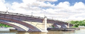
* Build a traffic oval at South Capitol, Potomac, Q, as the gateway to a new arched bascule-design Douglass Bridge that would have wide "multi-use trails" (i.e., sidewalks!) in both directions. The existing bridge would be demolished, after the new bridge is built somewhat downriver of the current location.
The Executive Summary (220 MB PDF) gives a good overview of the FEIS and preferred alternative (as it should!), but I also suggest wandering through the Chapter 2: Alternatives section, especially if you came to the neighborhood or JDLand after 2008 and didn't get to follow along during the EIS process, or if you're interested in the additional plans for east of the river, which I'm going to leave to others to discuss. My previous posts on all of this may be of interest as well. If you're wanting to see some of the earlier studies referenced in the FEIS, there are links to them at the top of my South Capitol Street project page.
How much would this all cost? The preferred alternative is priced in this final EIS at $806 million (not billion! yeesh) in FY 2014 dollars. (New bridges are expensive, you know.)
(I know that this is a very quick overview of a big study and plan, but there will be plenty of time to talk more about it, especially with the upcoming public meetings.)
Comments (2)
Update on South Capitol Street EIS, New Bridge
Feb 3, 2009 10:32 AM
ANC 6D heard a presentation on Monday night from the team working on the South Capitol Street Environmental Impact Statement, which is now in its "final preferred alternative" stage. Their PowerPoint presentation was pretty close to the one I posted last month, and one of the consultants did tweak me a bit about how I "spoiled the surprise" on the choice of the arched bascule design for the new Douglass Bridge.
Here again are the (long!) bullet points about what the preferred alternative designs are for the portion of South Capitol west of the Anacostia (see the presentation if you're interested in the preferred alternatives chosen for east of the river), along with some issues raised by the ANC:
* It was emphasized that these new designs will not be adding any capacity, but that the main goal is to bring back the "boulevard" feeling of the corridor.
* The new bridge will have 20-foot-wide sidewalks on each side, and only two piers will need to be built in the river, compared to 3-5 piers that would have been needed with the other designs. (The cable stayed swing bridge would have had just one pedestrian/bike path, 16 feet wide, in the middle of the bridge, surrounded by six lanes of traffic.)  * There will be a seven-acre traffic oval at the foot of the new bridge (which will be located to the south of the current bridge), reshaping the intersection of South Capitol Street and Potomac Avenue. (The ballpark's Home Plate Gate and entrance promenade will be the northeast edge of the oval.) The city is already in the process of acquiring seven properties or portions of properties that will be needed for the oval and bridge footprint, including the red brick warehouse on the northwest corner of South Capitol and Potomac. This oval is on the NCPC list of locations for future memorials and museums.
 * There will be a seven-acre traffic oval at the foot of the new bridge (which will be located to the south of the current bridge), reshaping the intersection of South Capitol Street and Potomac Avenue. (The ballpark's Home Plate Gate and entrance promenade will be the northeast edge of the oval.) The city is already in the process of acquiring seven properties or portions of properties that will be needed for the oval and bridge footprint, including the red brick warehouse on the northwest corner of South Capitol and Potomac. This oval is on the NCPC list of locations for future memorials and museums.
* The intersection of South Capitol Street and M Street will become an at-grade intersection (no more underpass for through traffic). ANC chair Andy Litsky expressed great concern about how this could make the intersection even more dangerous than it already is, to which the DDOT team replied that the reconfiguration should make it safer. (Certainly it would seem that having a "normal" intersection with two left-turn lanes in most directions would be an improvement safety-wise over the existing mish-mash of lights and poorly striped turn-lanes, but then there will also be a lot more cars cycling through once the tunnel lanes are gone.)
* There will be modifications to South Capitol's interchange with the SE/SW Freeway, with the replacement of the ramp that begins at I Street with an at-grade intersection underneath the freeway that would have two left-turn lanes to a new ramp. With the existing ramp removed, the intersection at South Capitol and I would also be reconfigured.
* The northern section of South Capitol Street will match the reconfigured portion between N Street and Potomac Avenue, as a six-lane boulevard with a median and wide sidewalks.
Commissioners McBee and Moffatt asked as they have in the past about whether the existing bridge could be kept as a pedestrian/bike-only bridge, but DDOT explained that since the swing span would continue to need to be opened for river traffic, the cost of maintaining the old bridge just isn't feasible. (The RiverFront folks might also be a teensy bit upset that their land that's beneath the current bridge wouldn't be coming back to them.) And the team also indicated that this new bridge does not preclude the construction (Some Day, Perhaps, in Some Far Off Time) of a tunnel to move non-local traffic from Anacostia to I-395.
They expect the final Record of Decision from the feds this fall; however, when pressed for a start date, they said 2011 would be the absolute earliest for the start of construction (with completion possibly in 2015), but that as of now there's no funding for the $700 million project. It's also possible that portions of the designs could be undetaken if partial funding is received.
Comments (1)
Special ANC 6D Presentation Meeting on Feb. 2
Jan 27, 2009 7:45 PM
With developers of three large projects needing to make presentations, ANC 6D has decided to have a separate presentation meeting on Feb. 2 in advance of its Feb. 9 monthly business meeting. And all three are Near Southeast spectaculars:
* The Housing Authority will be there to talk about the various modifications it's seeking to the Capper PUD, in advance of its March 19 Zoning Commission hearing;
* DDOT will be making a presentation on the final South Capitol Street Environmental Impact Statement (this includes the plans for the new Douglass Bridge), which I wrote about a few weeks back; and
* Forest City will be making a presentation about the park at the Yards (I believe these are the designs for Phase II, which include the various pavilions and the docks and marinas). The National Capital Planning Commission will be taking a look at Yards designs at their Feb. 5 meeting, and the Zoning Commission hearing on the park's second phase is scheduled for March 2.
The meeting is at the ANC 6D offices on the second floor of 1501 Half Street, SW, at 7 pm.
Comments (0)
More posts:
ANC News, Capper, meetings, South Capitol St., Douglass Bridge, The Yards, Yards Park, zoning
New Douglass Bridge: Arched Bascule-Riffic!
Jan 9, 2009 11:14 AM
On January 7, the city and federal agencies working on the various Anacostia Waterfront projects held their first "Interagency Coordinating Council" briefing of 2009, and were kind enough to post the PowerPoint slides (28 MB!) at theanacostiawaterfront.com. A number of Near Southeast projects are part of this domain, including South Capitol Street, the Frederick Douglass Bridge, and the 11th Street Bridges. Let's start with South Capitol Street, where the final designs for the reconfiguration of South Capitol Street (under the South Capitol Street EIS) appear to have been chosen (the "Final EIS Preferred Alternative"):
* The top headline is that the new Douglass Bridge is apparently going to be an arched bascule design (like the Memorial Bridge), with an opening span to allow for larger vessels to sail through.* There will be a large traffic oval at the foot of the new bridge (which will be located to the south of the current bridge), reshaping the intersection of South Capitol Street and Potomac Avenue. (The ballpark's Home Plate Gate and entrance promenade will be the northeast edge of the oval.)
* There will be a large traffic oval at the foot of the new bridge (which will be located to the south of the current bridge), reshaping the intersection of South Capitol Street and Potomac Avenue. (The ballpark's Home Plate Gate and entrance promenade will be the northeast edge of the oval.)* The intersection of South Capitol Street and M Street will become an at-grade intersection (no more underpass for through traffic).
* There will be modifications to South Capitol's interchange with the SE/SW Freeway. They aren't specified in this document, but based on my previous readings of the Draft EIS, I believe the final design will remove the existing ramp that begins at I Street with an at-grade intersection underneath the freeway that would have two left-turn lanes to a new ramp. With the removal of the existing ramp to I-395, the intersection at South Capitol and I would also be reconfigured.
* The northern section of South Capitol Street will match the reconfigured portion between N Street and Potomac Avenue, as a six-lane boulevard with a median and wide sidewalks.
* They expect to get a Record of Decision on the Final EIS from the Feds this fall. There's nothing in this document about a start date.
(Hopefully I'll find out more about the final EIS at Tuesday's ANC 6B meeting, so look for additional details on all of this in the coming days.)
As for the 11th Street Bridges, the file says that a demolition contract will be awarded this month for the decommissioned ramps to and from RFK, with the work expected to take place this spring. As for the big work to reconstruct the bridges, the city expects to choose a design/build team and have a contract with them by June 1, with the entire project slated to be completed by the end of 2013.
The PDF also has quick updates on the Anacostia Streetcar Project, the MLK Great Streets Initiative, the Anacostia Riverwalk Trail, the Parkside Pedestrian Bridge in Ward 7, and a new traffic circle at Pennsylvania and Potomac avenues. It's also got some good general bullet points on the South Capitol and 11th Street projects if you haven't been following up to now. I just hope you have a high-speed connection to download the entire 28-MB file. Otherwise, go get some lunch.
UPDATE: I've taken a little time to give both my South Capitol Street and Douglass Bridge pages a makeover with the new information (and boy, they needed it)--there's now some graphics pinched from the Draft EIS that do a better job explaining what the future plans are. I'd also suggest reading the executive summary of the 2008 Draft EIS, with the knowledge that most of the Design Alternative #2 options apparently have been chosen for the final design. It's a fair amount of detail, but worth it if you want to know how the project has reached its current state, and what's coming in the future. As I said, more to come as the city briefs neighborhoods and groups on the final EIS.
Comments (18)
New Douglass Bridge Design - Coming Soon? (Post on Upcoming Meetings)
Jan 5, 2009 8:38 PM
New Year, New Meetings:
* ANC 6B (mostly Capitol Hill, but also including the Eighth Street area of Near Southeast) has posted its January 13 meeting agenda, and one of the items on it is "South Capitol Street Draft Environmental Impact Statement." This draft EIS, which envisions substantial changes to the section of South Capitol Street from the Southeast Freeway across the Douglass Bridge to Firth Sterling Avenue, was released last year, and at December's Anacostia Waterfront Fair it was announced that the final EIS is expected to come this spring.
It may not sound like much to get excited about, but one of the cornerstones of the final EIS should be the unveiling of the chosen design for the new Douglass Bridge. I wrote a long entry about the Draft EIS when it was released, and on my Douglass Bridge page you can also see the four preliminary designs. (And you can also relive 2007's Extreme Makeover!) Feel free to sound off in the comments on which bridge design you want--but, please, no wagering.Also on ANC 6B's agenda is "ZC # 03-12I/03-13I, Modification to the Arthur Capper Carrollsburg PUD," which I imagine is the series of deadline extensions and other zoning items that I've previously written about. (UPDATE: This has apparently been removed from the 6B agenda, at the Housing Authority's request.)
This meeting is at the Old Naval Hospital, 921 Pennsylvania Ave., SE, at 7 pm.
* ANC 6D's monthly meeting will be on the previous night, Jan. 12, at St. Augustine's Church at 6th and M Streets, SW. No agenda yet posted. (6B usually wins this race by a country mile.)
* This Thursday (Jan. 8), Metro's Customer Service, Safety and Operations Committee will be voting on whether to authorize a mid-February hearing on the discontinuation of the N22 bus, which runs between the Union Station, Eastern Market, and the Navy Yard subway stations and which is expected to be replaced by DC Circulator route. I'm not sure why this is on the agenda again--my understanding was that they approved it in December, as did the full board. Read my previous posts with more detail on this change here and here.
Comments (5)
More posts:
ANC News, Capper, circulator, Metro/WMATA, South Capitol St., Douglass Bridge, Traffic Issues
Mini-Roundup: Metro Station Entrance Closed, Zoning News, Taxation w/out Representation Street Hearing
Nov 16, 2008 5:42 PM
A bunch of items to start the week with:
* Remember that the west entrance to the Navy Yard Metro station at Half and M is closed every evening this week from 8 pm until closing, thanks to work on 55 M Street.
* On Monday (Nov. 13), the Zoning Commission gave final approval to moving 225 Virginia Avenue into the Capitol South Receiving Zone, which will allow any construction on the block to have greater height and density than the 6.5 FAR/90-ft-height currently allowed. This was approved with two caveats: that there is Zoning Commission review of the design of the portions of a building proposed to rise higher than 90 feet to confirm that the building will be sufficiently setback from the eastern building face, and that any structure will provide a suitable northern focal point for the Canal Blocks Park. Read my entry from the hearing a few weeks ago for more information.
* On Nov. 24 at 2 pm, the city council will be having a hearing about B17-0909, the "Taxation Without Representation Street Renaming Act of 2008," which would "designate the portion of South Capitol Street, SE that intersects with N Street SE and Potomac Avenue SE as 'Taxation Without Representation Street, SE." It just so happens that this is the portion of South Capitol Street that runs alongside Nationals Park, where the council was thwarted in earlier attempts to install an electronic tote board showing the federal taxes that DC residents pay while still having no voting representation in the US Congress.
* Tommy Wells is taking nominations for the Second Annual Livable, Walkable Awards.
* For weeks I've been meaning to post that Nationals Park made the list of Travel and Leisure Magazine's "Must-See Green American Landmarks," thanks to being the first LEED-certified professional sports facility.
Comments (0)
More posts:
225 Virginia/Old Post Plant/200 I, 55 M St., Canal Park, meetings, Metro/WMATA, Monument Valley/Half St., South Capitol St., Nationals Park, zoning
Mayor Talks About Progress Along the Anacostia; Status Updates on Parks, Bridges, and the River
Nov 14, 2008 2:56 PM
This morning Mayor Fenty held a press conference at Nationals Park with various city officials to highlight tomorrow's Anacostia Waterfront Information Fair, and also talk up the recent progress and near-term next steps for the more than $8 billion worth of economic development, transportation, and infrastructure projects in the pipeline along the Anacostia River (not only in Near Southeast, but from the Southwest Waterfront all the way up past RFK).
Having sworn off taking any more photos of The Mayor at the Microphone (unless he shows up in a Hawaiian shirt and swimtrunks or something), I decided to record the 20-minute event instead, so that the five or six of you interested in hearing the remarks can do so. (It's a 2.6-mb MP3 file; the first few seconds are rough, but then it settles in.)
If you listen, you'll hear how the mayor managed to cajole the notoriously camera-shy Stan Kasten into saying a few words about what's happening along the river and in the neighborhood from the point of view of the area's largest tenant. Deputy Mayor Neil Albert, DDOT Director Frank Seales, Office of Planning head Harriet Tregoning, and the director of the city's Office of the Environment George Hawkins spoke as well. There was some discussion throughout (and especially at the end) about how the slowing economy might be impacting both the city's plans and developers' projects, but the mayor remains optimistic.
The press release from the mayor's office sums up the main points of today's event, but here's the Near Southeast-specific highlights from both the remarks and some other chatter of the day. First up, news of the three big parks:
The city "will break ground at Diamond Teague Park by the end of 2008." (And the guide for tomorrow's fair says that the park will be completed in spring 2009, which is the same date we've been hearing for a while.) The mayor also touted the operating agreement with Forest City Washington to build and maintain the $42 million, 5-acre Park at the Yards (but you knew about this already), as well as the the agreement with the Canal Park Development Corp. to build the $13.1 million, three-block-long park. (No mention of school buses.)
Then there's the bridges: Reconstruction of the 11th Street Bridges is scheduled to begin in mid-2009. (The shortlist of firms vying for the design-build contract was announced a few weeks ago.) Whether we actually see heavy equipment moving in mid-2009, or whether this just marks the first part of the design-build project is not quite clear. I was also told that the contract to demolish the flyover ramps to and from RFK could be completed soon, and that demolition would happen not long after the contract is signed.
Plus, the final Environmental Impact Statement for South Capitol Street and the Douglass Bridge is expected in spring 2009; that's when we'll hear which of the four bridge designs has been chosen.
As for the river itself, the city has started real-time water quality monitoring, updated automatically online 24 hours a day. There's also now the Anacostia 2032 Plan "to make the Anacostia River boatable, swimmable, and fishable in 25 years." And a Green Summer Jobs Corps was created earlier this year to "engage youth in the cleaning and greening of District neighborhoods and parks and to introduce them to green-collar job opportunities."
Finally, a planning process is underway to revamp Boathouse Row, the stretch of boat clubs along the Anacostia between 11th Street and Pennsylvania Avenue. (I took a bunch of photos near the boathouses a few months back, and have been lazy about ever getting them posted, though you can see a few boathouse-free shots of the environs here and here.)
There's more about projects elsewhere along the Anacostia, but other bloggers get to cover those. Will update this post if there's any media coverage from today's event, and will have a fresh post on Saturday after the fair. I imagine I'll Twitter a bit from those festivities (like I did from today's); remember that if you aren't a Twitter-er, you can read my tweets on the JDLand homepage--check 'em out frequently, because I do sometimes post news there first, before I write full blog entries.
SATURDAY FAIR UPDATE: They're now going to be providing free shuttle bus service from the New Jersey & M Metro entrance to/from the ballpark, from 12:30 pm to 5:15 pm. (After they heard somewhere that the Half and M subway entrance is going to be closed on Saturday.)
Comments (1)
More posts:
11th Street Bridges, Boathouse Row, Canal Park, Douglass Bridge, Nationals Park, Teague Park, The Yards, Yards Park
Monday Meetings; Parking Signs; Birds-Eye View
Mar 9, 2008 3:18 PM
* I mentioned this a few days back, but why not pass along another reminder that Monday at 7 pm is the ANC 6D monthly meeting, with presentations and votes on 401 M Street, the ballpark traffic management plan, and the South Capitol Street Draft EIS, plus a briefing by the Nats on the Opening Day "Fan Fest" activities. To get in on the fun, go to St. Augustine's Episcopal Church at 6th and M St., SW, starting at 7 pm.
* If the ANC isn't your bag, you can watch the Zoning Commission take up again the Capitol Gateway Overlay Review for Donohoe's planned office building at 1111 New Jersey. It's a continuation of the last hearing, which revolved mostly around whether the garage access would be from New Jersey or from the alley. The hearing starts at 6:00 pm, and 1111 is also on the public meeting agenda at 6:30 pm, which perhaps is a display of optimism that Donohoe and DDOT will have the garage issue straightened out and the review ruling can be made. Watch the webcast, if you're so inclined. (I'm going to be missing both of these meetings, so it might be a few days before I can get the scoop on them.)
* The new Enhanced Residential Parking Permit signs, which allow non-Zone 6 parking only on one side of the street in certain areas near the ballpark, continue to get installed. They came to my street north of the freeway within the past day or so.
* I thought I did good with last week's find of a November 2006 satellite photo of the neighborhood, but reader JK has upped the ante with the "Bird's-Eye View" option at Microsoft Live Search, showing not-real-high-up images from March 2007. But be careful when you're scrolling around--if you go to fast, the images flip back to shots from early 2003. (Which is festive in its own fun-house kind of way.)
Comments (2)
More posts:
1111 New Jersey/Insignia on M, ANC News, parking, South Capitol St., Square 743N, Nationals Park, zoning
Tidbits: Permits, Yards Names, No SE Freeway?, South Cap Tunnel, 55 M Web Cam, A New Crusade
Mar 8, 2008 10:48 AM
Just a bunch of tiny items worth highlighting on a dreary Saturday (no new photos today in this muck):
* A building permit has been approved to build a surface parking lot along First Street between M and N, where Normandie Liquors and its brethren were demolished last month. And the Archdiocese of Washington has applied for a public space permit for the 1300 block of First Street, SE--does the Popemobile need special parking permits?
* As plans at The Yards continue to move forward, there's now official names for the first-phase projects. Say hello to The Boilermaker Shop, The Pattern Shop Lofts, and Factory 202. (And 401 M and 400 Tingey, but those aren't anywhere near as catchy.)
 Beginning the trek through the approvals process are the first new-construction buildings planned for The Yards--a 320,000-square-foot office building at 401 M Street and a 170ish-unit apartment building to its south at 400 Tingey Street. They would both have ground-floor retail, but it's what's planned for 401 M that will probably have everyone's attention, because a grocery store is proposed for that space, just inside the historic wall and sentry tower on the southeast corner of Fourth and M. (No, which grocery store it could be hasn't been announced yet.) Recent documents have said that 401 M could begin construction in late 2008, with delivery in 2010; the residential building's start depends on "market conditions." (Uh-oh.) A few more early renderings are on my 401 M/400 Tingey page. (See my Yards First Phase page for information on the retail and residential projects that are getting underway this year.)
* The 55 M web cam is no longer available to the public. Perhaps they want the Opening Day vista to be a big surprise. Or they don't want people watching the last-minute work on the Navy Yard Metro station. (I wonder if the gas main hit on Thursday was caught by this camera.)
* Some commenters are discussing the idea that's been floated of someday demolishing the Southeast-Southwest Freeway. Getting rid of this Berlin Wall that separates Capitol Hill and Near Southeast (and splits Southwest) was brought up in the National Capital Planning Commission's 1997 Extending the Legacy framework plan, if you want to see it actually on paper. (Apparently an updated NCPC framework plan is scheduled to come out this spring, which looks like it continues to have Virginia Avenue marked where the freeway currently is.) As to whether I'll see this done in my lifetime, well, it would be a nice surprise.
If you really want to go high-concept, you can read DDOT's 2003 South Capitol Street Gateway and Improvement Study to see their ideas for a tunnel that would link I-295 and the SE/SW Freeway for through traffic, leaving South Capitol Street to become the grand urban gateway boulevard planners envision. At Wednesday's public meeting on the South Capitol Street Draft Environmental Impact Statement, DDOT said that the tunnel isn't totally off the table, but they decided that a new Douglass Bridge and other South Capitol Street improvements could move forward separately. But could a tunnel still work if the dream of dismantling the SE/SW Freeway were realized?
* I've tried to remain (mostly) unopinionated on various projects during the five years I've run this site. But sometimes, it's necessary to take a stand, to come out from behind the cloak of neutrality and crusade for what you believe in. So I'm going to take advantage of this bully pulpit and fight for one thing: Arched Bascule!
Comments (12)
More posts:
55 M St., Boilermaker Shops/Yards, Factory 202/Yards, Foundry Lofts/Yards, Metro/WMATA, Monument Valley/Half St., South Capitol St., Douglass Bridge, Nationals Park, Traffic Issues, Square 701, The Yards, Twelve12/Teeter/Yards
Hearings on First New Buildings at the Yards; Ballpark and South Capitol EIS Also on ANC 6D Agenda
Mar 7, 2008 8:49 AM
There's a Zoning Commission Southeast Federal Center Overlay Review of the plans scheduled for April 17, and ANC 6D will be voting on whether to support the project at its March 10 meeting.
Also at Monday's ANC 6D meeting will be presentations and votes on plans for the Opening Day Fan Fest at the ballpark, the ballpark Transportation and Residential Curbside Management Plan (formerly known as the TOPP), and the South Capitol Street Draft Environmental Impact Statement. I attended Wednesday night's public meeting on the Draft EIS, and while the slides from the meeting haven't yet been posted on its web site, the DEIS's executive summary is a good substitute for the information that was available at the meeting--you can read my summary of the plans as well. There wasn't much public comment (maybe seven or eight speakers), and the concerns seemed to be more about making sure DDOT does a good job of handling the inconveniences and resident issues as a result of the planned changes, rather than any real opposition to the plans themselves. The public comment period ends March 31, and the Final EIS is expected to come out late this year.
Alas, I won't be able to attend this ANC meeting that's so chock full of Near Southeast goodness. But I'm guessing that spending that evening watching the Roger Federer-Pete Sampras exhibition at Madison Square Garden might be a bit more enjoyable.
Comments (0)
More posts:
ANC News, parking, Retail, South Capitol St., Douglass Bridge, Nationals Park, Traffic Issues, The Yards, Twelve12/Teeter/Yards, zoning
Monday Morning Roundup and Reminders
Mar 3, 2008 11:01 AM
* The tarp is coming off the field today--look at that pretty turf! It's probably being done today because Tuesday the Nats are holding a ceremony to install home plate and officially unveil the HD scoreboard (not open to the public).
* The Examiner reports that Metro is tamping down expectations a bit for performance along the Green line for weeknight ballgames: "The transit agency expects the number of riders on the Green Line, which serves the Navy Yard station near the ballpark, to more than triple on game days. But Metro can't add more cars to that section of the system during the week because all of its 820 railcars are committed to rush hour service, officials said." So, perhaps that notion of walking from Capitol South is looking more attractive--I've added to my Take Metro! page a map of the JDLand Suggested Route between Capitol South and the stadium, along with a few photos showing the current state of New Jersey Avenue (which certainly isn't as scary as it used to be).
And, Tuesday is just chock full of Near Southeast-related activities. In addition to the ceremony mentioned above, there's also these items to remember:
* Single-game ticket sales open at 9 am (yes, including Opening Day).
* The City Council will be meeting at 10 am for its monthly legislative meeting, and the agenda includes emergency legislation to enact the "Performance Parking Pilot Zone Emergency Act of 2008", B17-0644, the "Ballpark Safety Emergency Amendment Act of 2008", and B17-0608, the "Vending Regulation Emergency Act of 2008". It's in Room 500 of the Wilson Building, beginning at 10 am, and will be broadcast on DC cable 13 and live webcast.
* The first of two public meetings on the South Capitol Street Draft Environmental Impact Statement is at 6:30 pm at Birney Elementary School, 2501 Martin Luther King Jr., Ave., SE, from 6:30-8:30 pm. The second one is Wednesday night (March 5) at Amidon Elementary School, 401 I St., SW, also from 6:30-8:30 pm.
Comments (2)
Roundtable on Traffic Operations and Parking Tonight
Feb 28, 2008 10:22 AM
Passing along a reminder, via my Ballpark and Beyond column in today's District Extra of the Post: "A roundtable by two D.C. Council committees on the city's plans for traffic and parking at Nationals Park begins at 6 tonight in Room 120 of the Wilson Building. Considering that the last hearing on stadium-related parking issues lasted until almost midnight, you might prefer to watch tonight's session in the comfort of your home, where you'll have access to your kitchen cabinets and coffee maker. The roundtable can be seen on Channel 13 on D.C. cable systems or on the Web."
I won't be able to watch it live, but hopefully I can post a summary of it before too long, unless the current focus on the stadium by the local media takes care of it for me. If so, my feelings wouldn't be hurt. Really. It's all yours.
I should mention here that what's long been known as the Draft Transportation Operations and Parking Plan (TOPP) is now apparently the final version of how traffic is going to be handled, at least until they see how it works on Opening Day and then start tweaking it (which DDOT and other agencies fully expect to be the case). So if you want to know the nitty-gritty of traffic and pedestrian flow, the TOPP is the place to look. And I imagine the residents testifying at tonight's roundtable might have an issue or two with it.
Other items in today's column were the latest tidbits on Diamond Teague Park, a reminder of the meetings next week on the South Capitol Street Draft Environmental Impact Statement, and photos of the new freeway and bike route signage pointing to the ballpark. And just a note that the column will be taking the next two weeks off, and will be back on March 20--if there's anything left for me to write about that isn't already covered in this All Things Ballpark media blitz.
Comments (0)
Ballpark and Beyond Column This Week
Feb 21, 2008 9:40 AM
My Ballpark and Beyond column in today's District Extra of the Post covers last week's release of the Draft Environmental Impact Statement for South Capitol Street, the impending closure of Metro's Southeastern Bus Garage at Half and M, tonight's zoning hearing on allowing additional temporary surface parking lots in Southwest, and a reminder about today's ballpark job fair.
(And I've been under the weather the past few days, hence the somewhat brief updates.)
Comments (1)
South Capitol Street Draft EIS Available
Feb 15, 2008 10:28 AM
The Draft Environmental Impact Statement that describes two alternatives for reconfiguring South Capitol Street from just south of Firth Sterling Avenue north to I-395 has now been released, and is available online: there's the compact executive summary for folks who just want the basics, or the full shebang, with 80-plus chapters, appendices, and reports. Note that this draft EIS does not include a final choice for the design of the new Douglass Bridge that would be built to the southwest of the current bridge, though that decision will be made with the final EIS. (I'm a fan of the arched bascule design, because I'm old school.) There's no way I'm going to try to provide a comprehensive overview of what this project is envisioning, so here's some bullet points:
* For Near Southeast, both build alternatives would reconfigure the intersection with the SE/SW Freeway, replacing the existing ramp that begins at I Street with an at-grade intersection underneath the freeway that would have two left-turn lanes to a new ramp. With the removal of the existing ramp to I-395, the intersection and South Capitol and I would also be reconfigured. Also included in this project would be streetscape improvements to New Jersey Avenue, with two travel lanes and two parking lanes and much wider tree-lined sidewalks.
* The main differences between the alternatives for this northern stretch of South Capitol Street are the intersections with Potomac Avenue and with M Street. At Potomac Avenue, there would be either a reconfigured signalized intersection or a large traffic oval connecting South Capitol, Potomac, Q Street, and the new Douglass Bridge. At M Street, a decision will be made between keeping the current underpass for north/south traffic or replacing it with an at-grade intersection. And, in the second build alternative, the K and L street intersections would be opened to cross traffic. There are also many changes planned for South Capitol Street and the Suitland Parkway south of the Douglass Bridge, which are spelled out in the Alternatives section if you're interested. (I'm waiting for a reply from DDOT about whether portions of each build alternative can be chosen a la carte to create a final alternative. UPDATE: As was the case with the 11th Street Bridges EIS, the final plans can indeed take some portions of one alternative and some from the other. So it's possible, as an example, that the traffic oval from alternative #2 could be chosen, but the unchanged M Street intersection from alternative #1 could be chosen, too.
* Depending on which alternatives and which bridge design is chosen, the Draft EIS puts the estimated costs for this project at anywhere between $508 million and $781 million. Flyers given out at the Anacostia Waterfront Community Fair last month indicated that construction on the new Douglass Bridge could begin in 2010, with completion in 2015. The Draft EIS doesn't seem to lay out any timeline for completion of the entire South Capitol Street project.
There are two public meetings planned to discuss the Draft EIS: on March 4 at Birney Elementary School, 2501 Martin Luther King Jr., Ave., SE, and on March 5 at Amidon Elementary School, 401 I St., SW. Both will run from 6:30 to 8:30 pm. The public comment period ends on March 31, and methods for submitting your comments are spelled out on the report site. You can also see print versions of the Draft EIS at a number of local libraries in the area.
Comments (1)
More posts:
South Capitol St., Douglass Bridge, Traffic Issues
South Capitol Draft EIS Now Scheduled for Friday
Feb 11, 2008 9:06 AM
At the Anacostia Waterfront Community Fair a few weeks back, I picked up a card that indicated South Capitol Street Draft Environmental Impact Statement (which is centered around the construction of a new Douglass Bridge) would be released on Feb. 8. So, all last week, I kept checking in at southcapitoleis.com just to see if the site had been updated or if there were any "Coming Soon" announcements. Nada. Imagine my surprise, then, when on Saturday I received a brochure via snail mail (how wonderfully old school!) announcing the the EIS would be released on Feb. 15, with the two public meetings pushed to March 4 and 5, and the deadline for public comment moved to March 31. The web site still makes no mention of the impending release, though you can see the two build alternatives being evaluated. More about this when the draft is actually released.
Comments (3)
More posts:
South Capitol St., Douglass Bridge, Traffic Issues
Waterfront Fair Tidbits (250 M, Bridges, More)
Jan 26, 2008 7:22 PM
This afternoon's Anacostia Waterfront Community Fair appeared to be very well attended, at least during the 90 minutes or so I was there. (Even Marion Barry showed up.) There were three long tables of displays and information from city agencies, commercial developers, and non-profit organizations, and Near Southeast was well-represented--JPI, Velocity, Monument Half Street, Williams C. Smith (250 M Street), Forest City (Capper/Carrollsburg, The Yards), the Anacostia Community Boathouse Association, and the ballpark all had people on hand. (There was also plenty of swag--hope you didn't miss out on your DC WASA lanyard!)
Two news items I came across:
* First, confirmation that 250 M Street will start construction in either late spring or early summer, although they don't yet have any office or retail tenants to announce.
* Second, the Draft Environmental Impact Statement for South Capitol Street (including a new Frederick Douglass Bridge) is going to be released on February 8, with a public comment period to follow. There are two build alternatives that would reconstruct South Capitol Street and the Suitland Parkway (and its interchange with I-295), but neither has been identified yet as a "preferred" alternative. (No design from the four options for a new Douglass Bridge has been chosen yet, either.) There will be public meetings in late February about the Draft EIS, and the web site will be updated soon with information on the draft. I'll write more about this when the Draft EIS is officially released, but it's this study that will decide whether a big traffic oval is built at South Capitol and Potomac, and whether the South Capitol/M interchange could be reconfigured into an "at-grade" intersection (i.e., no more tunnel).
I should have asked about the status of the reconfiguration of the 11th Street Bridges now that that EIS is complete, but I could never get close enough to the table to talk to anyone. (See update below.)
Other developments such as the Southwest Waterfront and Hill East had displays as well, but since my brain can't process anything outside of my borders, you'll have to hunt down information on those projects elsewhere.
UPDATE: I'm finally looking through the pile of flyers I picked up, and here's a few timelines in the official brochure for the event (they're called "targeted schedules", so best not to pen them in just yet):
* Douglass Bridge Replacement: Begin construction Spring 2010, complete in Winter 2015.
* 11th Street Bridges Replacement: Begin construction Spring 2009, no completion date listed.
Also, the 500,000-sq-ft office building by Forest City at the site of the old Capper Seniors building at 600 M has a Spring 2009 start date in one of Forest City's flyers. The other Yards start/completion dates in the brochures are on target with what I've written about previously (see my Yards Phase I page for details).
Comments (0)
More posts:
11th Street Bridges, 250 M/New DDOT HQ, 600 M/Square 882/Old Capper Seniors, Boathouse Row, M Street, South Capitol St., Douglass Bridge, Traffic Issues, The Yards
The Near Southeast Traveling Road Show, On Demand
Nov 23, 2007 9:26 AM
During my poking around on the DC Office of Cable Television web site recently, I discovered that many of the groundbreakings and other events in Near Southeast this year that have been broadcast on the city's cable channel 16 are also available On Demand; the same goes for council hearings, available on Channel 13's On Demand page. (I kinda sorta knew that the On Demand stuff was there, but when I checked it many moons ago, it didn't seem quite so complete, so I hadn't looked back in on it for a while.)
So if you've missed any of the following four-star telecasts from 2007, you can watch them at your leisure:
* The Oct. 3 groundbreaking ceremony at The Yards;
* The Aug. 27 ceremony marking the reopening of the Frederick Douglass Bridge (and, for that matter, the time-lapse video of the lowering in July);
* The July bill-signing ceremony at the Earth Conservations Corps pumphouse where the Anacostia Waterfront Corporation and the National Capital Revitalization Corporation were officially abolished;
* JPI's June "groundbreaking" for its four projects along I Street ("Capitol Yards");
* The April presentation of $4 million for Canal Park/Diamond Teague Park;
* The January groundbreaking marking the start of the Navy Yard Metro renovation and Monument's Half Street project;
* And pretty much any ceremony anywhere in the city the mayor was at since the beginning of the year, plus a lot of other presentations and events. (Be sure not to miss the Reporters' Roundtable "Snitching Debate.") Check the dropdown boxes on the On Demand page for the offerings. I've added the above links to all of the various project pages in case you're desperate to find them again someday.
Two of the most recent shindigs haven't gotten added to the lineup yet--the Oct. 22 kickoff ceremony for the Capitol Riverfront BID (in which you can find out where the "Traveling Roadshow" moniker originated), and the mayor's remarks at the Nov. 13 turf unveiling at the ballpark. Ditto with the Waterside Mall Demolition program, which is currently playing on Channel 16 but hasn't yet made it to On Demand. But perhaps they'll show up eventually.
Quick Links: Parking, Bridges, Streetcars
Nov 23, 2007 9:12 AM
I just can't bear to go completely dark for too many days in a row, so here's some light reading for your post-turkey haze:
* These are almost a month old now (oops), but the Hill Rag has an opinion piece on the plans for the 11th Street Bridges, plus an article on the community concern on Capitol Hill and in Southwest over the planning for ballpark parking.
* Today's Washington Business Journal looks at the plans for the return of streetcars to DC, a very long-term project that could eventually have light rail running down M Street SE and across both the 11th Street and Douglass bridges. But that's a loooong ways off--first they have to finally get a long-delayed test line in Anacostia off the ground, and then the H Street NE corridor would be next. There used to be a good web site on the project at DCTransitFuture.com, but that site is now hijacked with a fake blog, so the best I can give you is this DDOT page with a few links.
* There's also a WBJ article on PNC Bank securing the naming rights to the Diamond-level seats (the second priciest) and the club lounge at the ballpark. Still no word on naming rights for the stadium itself, though a few weeks ago we heard that there might not be a sponsor during the inaugural season.
More posts:
11th Street Bridges, M Street, parking, Douglass Bridge, Nationals Park, streetcars, Traffic Issues
14th Street Bridge Corridor EIS Meeting on Oct. 10
Oct 9, 2007 11:45 AM
(Boy, I really want to ignore this, since 99 percent of it falls outside my cast-in-stone boundaries, but it's a slow day, so....) Tomorrow (Oct. 10) there's a Public Information Meeting about the 14th Street Bridge Corridor Environmental Impact Statement Study. Quoting: "The purpose of this study is to identify actions that can reduce congestion, enhance safety, and improve traffic operations in the 14th Street Bridge corridor." They're looking for congestion and safety solutions and ideas, and also are looking for ways to make the "existing corridor work more efficiently." The scope of the study area runs along I-395 from just east of South Capitol Street all the way to Glebe Road, and east to Route 1 in Virginia and south to M Street in Southwest. See the flyer for additional details. It's from 6:30 to 8:30 pm at Amidon Elementary School, 401 I Street, SW.
UPDATED because I can't read a calendar. Tomorrow is the 10th.
More posts:
South Capitol St.
11th Street Bridges Rehab in 2009?
Aug 3, 2007 11:50 AM
In a Post article today surveying the state of DC-area bridges in the wake of the 35W Bridge collapse in Minneapolis, there is this little item of note: "For instance, there are plans for a major overhaul and redesign of the 11th Street Bridge beginning in 2009, according to [DDOT] spokesman Erik Linden." The Environmental Impact Study completed last year came up with a number of potential reconfigurations of the 11th Street Bridges to allow for traffic to exit and go northward on DC-295 (instead of having to cross the Anacostia on Pennsylvania Avenue and then make that hair-raising left turn). Visit the 11th Street Bridges EIS web site if you're interested in what the plans are, although we're still waiting for the official announcement of which configuration has been chosen.
And, of course, in the wake of Minneapolis, the two-month closure of the Douglass Bridge for not only the reconfiguration of its north end but also considerable work on its deck and undersides might be seen in a different light now....
14th Street Bridge Corridor EIS Underway - And Other Enthusiastic Boundaries
Feb 7, 2007 9:43 PM
You would think that a new Environmental Impact Statement of the 14th Street Bridge Corridor would be outside of my Near Southeast scope, but they managed to sneak the boundary area just past South Capitol Street. So, it becomes another study I will grudgingly pay attention to, along with the South Capitol Street EIS and the 11th Street Bridges EIS (both of which have gone reeeeeal quiet lately, with the 11th Street Bridges EIS having missed its release deadline of Fall 2006). See this flyer for information on the 14th Street Bridge Corridor public workshops, on Feb. 27 at Amidon Elementary in Southwest and Feb. 28 in Arlington.
And speaking of Boundary Creep, the Washington Business Journal reported last week that the Office of Planning has "has initiated a major effort to expand the boundaries of the traditional office and entertainment areas, creating a planning zone called Center City. The initiative more than doubles the area traditionally considered downtown by adding the North of Massachusetts Avenue area (NoMa) as well as the Southeast and Southwest waterfronts. Another objective is to provide better links to tie the traditional downtown zone with emerging business and entertainment districts, the waterfront and the National Mall. Center City will be promoted as a waterfront city with nearly half of its boundary defined by the Potomac and Anacostia rivers." You can see the OP's Center City page for more details about this project, which I am admittedly giving short shrift here (I figure there will be plenty more items to come). Who'd a thunk it--it turns out Near Southeast is DOWNTOWN, baby!
More posts:
11th Street Bridges, South Capitol St.
Overview Piece on New Douglass Bridge
Apr 13, 2006 8:04 AM
In today's Post (well, in some of them, depending on which Extra you receive) is "For Commuters, A New Way to Travel Through the District," a good overview piece about the plans for a new South Capitol Street/Frederick Douglass Bridge. The article doesn't have anything new, but it brings together all the bits and pieces that have come out over the past months about the new bridge. It mentions the public meeting scheduled for May 4, and also confirms that sometime this summer two blocks of the "elevated" South Capitol Street (from O Street to Potomac Avenue) will be dismantled, allowing South Capitol Street to be "at-grade" alongside the stadium site. And it also says, as we've heard previously, that construction would not begin before 2011; the final design of the bridge will be chosen this summer, after the Environmental Impact Study is completed. Cost estimates range from $285 million to $392 million, based on the design. Make sure to go to the poll to vote for your favorite design!
More posts:
South Capitol St., Douglass Bridge, Traffic Issues
South Capitol Street Community Update Meeting
Apr 7, 2006 1:41 PM
DDOT will be holding a public meeting on May 4 at 6 pm to update the public on the latest South Capitol Street Corridor news, and also to allow public review and comment on the latest plans for the street and also the South Capitol Street Bridge. The South Capitol Street EIS and South Capitol Street Bridge Study web sites have more information about what's on tap.
More posts:
South Capitol St., Douglass Bridge, Traffic Issues
More on New South Capitol Street Bridge and Street Improvements
Mar 10, 2006 5:11 PM
There's more links and information available now about the possible designs unveiled on Wednesday for the new South Capitol Street Bridge.You can see fun 3D videos of the different designs at the South Capitol Street Bridge Study site. (Do you think we can infer from the number of different videos available for each option that the "Cable Stayed Swing Bridge" might be the designers' favorite?) There is also a press release from DDOT, saying that there will be a community meeting in April to solicit comments on the design, and also to give an update on the project. The draft Environmental Impact Statement will be released in June. And, a bit more detail on the interim work that will be done on the existing bridge: "Starting this summer, the bridge will be rehabilitated to ensure its continued safety and use. The work includes new lighting, better sidewalks and a new coat of paint. In addition two blocks of the elevated viaduct will be removed and replaced with an at-grade roadway, greatly improving the appearance and pedestrian access along South Capitol Street
More posts:
South Capitol St., Douglass Bridge, Traffic Issues
South Capitol Street EIS Newsletter
Feb 24, 2006 10:11 AM
The South Capitol Street Environmental Impact Statement project has posted its Winter 2006 newsletter with the latest updates on the study. Two build alternatives have been identified and are briefly described--the less costly one would keep the South Capitol and M intersection in two levels, and would create a "traditional" intersection at Potomac Avenue. The second and more wide-ranging alternative would reconstruct South Capitol and M to be "at-grade", and would create a traffic circle interchange at Potomac Avenue (there are differences in the two plans for east side of the bridge as well). The various plans (the two build alternatives, plus a "Transportation System Management" alternative and a No-Build alternative) will be presented at public meetings later this winter, then there will be ANC meetings, environmental analyses, and finally the preparation of the draft EIS. In the meantime, DDOT will be discussing this project as part of its Feb. 25 Open House. Also, both the South Capitol Street EIS and the 11th Street Bridges EIS teams will present their pedestrian and bicycle concepts to a meeting of the Bicycle Advisory Council on March 8. See my South Capitol Street and South Capitol Street Bridge pages for more details, photos, links, etc.
Speaking of bridges and environmental impact statements, I've only now stumbled across both the South Capitol Street Bridge Study web site and SouthCapitolEIS.com, two efforts that ran concurrently over the last six months as part of the project to replace the Frederick Douglass Bridge. (I've only been checking the DDOT Public Meetings page on a daily basis for weeks now, sure would have been nice if one of their announcements had ever mentioned these URLs!) Both sites have lots of links and information, and should be required bookmarks for anyone interested in the replacement (and most likely realignment) of the South Capitol Street Bridge. Materials from the summer meetings of these projects are available, as is a mammoth, crash-your-computer PDF showing two of the proposed alternate alignments. I believe these two stages are pretty much over, so I'll try to keep you posted on the next phases.
More posts:
South Capitol St., Douglass Bridge, Traffic Issues