
|
| |||||||||||||||||||

|
Please note that JDLand is no longer being updated.
peek >>
Near Southeast DC Past News Items: Oct 26, 2006
- Full Neighborhood Development MapThere's a lot more than just the projects listed here. See the complete map of completed, underway, and proposed projects all across the neighborhood.
- What's New This YearA quick look at what's arrived or been announced since the end of the 2018 baseball season.
- Food Options, Now and Coming SoonThere's now plenty of food options in the neighborhood. Click to see what's here, and what's coming.
![-]()
- Anacostia RiverwalkA bridge between Teague and Yards Parks is part of the planned 20-mile Anacostia Riverwalk multi-use trail along the east and west banks of the Anacostia River.
![-]()
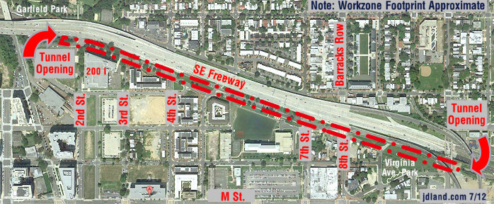
- Virginia Ave. Tunnel ExpansionConstruction underway in 2015 to expand the 106-year-old tunnel to allow for a second track and double-height cars. Expected completion 2018.
![-]()
- Rail and Bus Times
Get real time data for the Navy Yard subway, Circulator, Bikeshare, and bus lines, plus additional transit information. - Rail and Bus Times
Get real time data for the Navy Yard subway, Circulator, Bikeshare, and bus lines, plus additional transit information. - Canal ParkThree-block park on the site of the old Washington Canal. Construction begun in spring 2011, opened Nov. 16, 2012.
![-]()
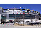
- Nationals Park21-acre site, 41,000-seat ballpark, construction begun May 2006, Opening Day March 30, 2008.
![-]()
- Washington Navy YardHeadquarters of the Naval District Washington, established in 1799.
![-]()
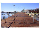
- Yards Park5.5-acre park on the banks of the Anacostia. First phase completed September 2010.
![-]()
- Van Ness Elementary SchoolDC Public School, closed in 2006, but reopening in stages beginning in 2015.
![-]()
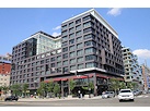
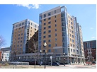
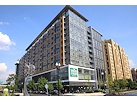
- Agora/Whole Foods336-unit apartment building at 800 New Jersey Ave., SE. Construction begun June 2014, move-ins underway early 2018. Whole Foods expected to open in late 2018.
![-]()
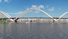
- New Douglass BridgeConstruction underway in early 2018 on the replacement for the current South Capitol Street Bridge. Completion expected in 2021.
![-]()
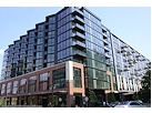
- 1221 Van290-unit residential building with 26,000 sf retail. Underway late 2015, completed early 2018.
- NAB HQ/AvidianNew headquarters for National Association of Broadcasters, along with a 163-unit condo building. Construction underway early 2017.
- Yards/Parcel O Residential ProjectsThe Bower, a 138-unit condo building by PN Hoffman, and The Guild, a 190-unit rental building by Forest City on the southeast corner of 4th and Tingey. Underway fall 2016, delivery 2018.
- New DC Water HQA wrap-around six-story addition to the existing O Street Pumping Station. Construction underway in 2016, with completion in 2018.
- The Harlow/Square 769N AptsMixed-income rental building with 176 units, including 36 public housing units. Underway early 2017, delivery 2019.
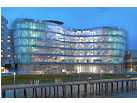
- West Half Residential420-unit project with 65,000 sf retail. Construction underway spring 2017.
![-]()
- Novel South Capitol/2 I St.530ish-unit apartment building in two phases, on old McDonald's site. Construction underway early 2017, completed summer 2019.
![Novel South Capitol]()
- 1250 Half/Envy310 rental units at 1250, 123 condos at Envy, 60,000 square feet of retail. Underway spring 2017.
![-]()
- Parc Riverside Phase II314ish-unit residential building at 1010 Half St., SE, by Toll Bros. Construction underway summer 2017.
![-]()
- 99 M StreetA 224,000-square-foot office building by Skanska for the corner of 1st and M. Underway fall 2015, substantially complete summer 2018. Circa and an unnamed sibling restaurant announced tenants.
![-]()
- The Garrett375-unit rental building at 2nd and I with 13,000 sq ft retail. Construction underway late fall 2017.
![-]()
- Yards/The Estate Apts. and Thompson Hotel270-unit rental building and 227-room Thompson Hotel, with 20,000 sq ft retail total. Construction underway fall 2017.
![-]()
- Meridian on First275-unit residential building, by Paradigm. Construction underway early 2018.
![-]()
- The Maren/71 Potomac264-unit residential building with 12,500 sq ft retail, underway spring 2018. Phase 2 of RiverFront on the Anacostia development.
![-]()
- DC Crossing/Square 696Block bought in 2016 by Tishman Speyer, with plans for 800 apartment units and 44,000 square feet of retail in two phases. Digging underway April 2018.
![DC Crossing]()
- One Hill South Phase 2300ish-unit unnamed sibling building at South Capitol and I. Work underway summer 2018.
![One Hill South Phase 2]()
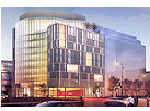
- New DDOT HQ/250 MNew headquarters for the District Department of Transportation. Underway early 2019.
![New DDOT HQ]()
- 37 L Street Condos11-story, 74-unit condo building west of Half St. Underway early 2019.
![37 L Condos]()
- CSX East Residential/Hotel225ish-unit AC Marriott and two residential buildings planned. Digging underway late summer 2019.
![CSX East Residential/Hotel]()
- 1000 South Capitol Residential224-unit apartment building by Lerner. Underway fall 2019.
![1000 South Capitol Residential]()
- Capper Seniors 2.0Reconstruction of the 160-unit building for low-income seniors that was destroyed by fire in 2018.
![1000 South Capitol Residential]()
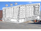
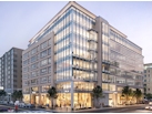
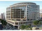
- Chemonics HQNew 285,000-sq-ft office building with 14,000 sq ft of retail. Expected delivery 2021.
![1000 South Capitol Residential]()


4 Blog Posts
Local blogs are buzzing today about the DC government's launch of crimemap.dc.gov, which allows users to drill down by address, neighborhood, ANC, Ward, whatever, and get a graphical representation of reported crimes. It's using the same DC Stat RSS feed that I've used to launch my Near Southeast Crime Incidents list (which has been wonderfully low on new data recently!). But if you're looking for a splashy graphic version to display crime trends, rather than my boring text-only list, give it a shot (but be warned, it's moving very slowly today thanks to all the publicity). And remember to scroll down and check my Near Southeast Data Feeds box every day--the crime and public space permits are updated by noon, the building permits update in the late evenings, and the recent property sales (which have a lag time of about six weeks) update once a week or so depending on the city's interest in updating their database. UPDATE: I've also tinkered with my Data Feeds box to show all currently in-effect public space permits, in addition to new/updated applications, as well as to expand the timeframe on offerings to 14 days from seven. I can't imagine this interests anyone other than me, but just in case....
|
More posts:
|
GlobeSt.com has a brief on MacFarlane Partners, the San Francisco-based real estate investment firm that has fronted 25% of the capital for the development of the Southeast Federal Center (hey, buddy, that's "The Yards" to you!). The article says that "the company plans to make significant investments in the Baseball district" and that "MacFarlane says he expects to announce three mixed-use projects in the area by the end of the year. These will consist of residential, retail and office totaling some $300 million to $400 million. Right now these projects are in the early planning stage, but MacFarlane says that, depending on the density patterns, he expects the projects will cover between one million sf to two million sf." I've seen MacFarlane mentioned recently as part of the group working on Herb Miller's stadium garages plan, but I don't know whether this statement about the three soon-to-be-announced projects would include the garages, or if it includes any part of the SFC/Yards, or if it's partnering with Forest City and Western Development (Herb's company) on the AWC's drive to develop the WASA site, or if it's three completely new projects. I guess we shall see. (Read the GlobeSt brief quick, because they archive after seven days.)
|
|
The Oct. 27 Voice of the Hill is now posted online, with it's extensive coverage of the Nov. 7 local elections--Near Southeast is in Ward 6 and ANC 6D (single-member district 6D07). Get yourselves good and educated, and then vote!
|
More posts:
|
From the DC Examiner: "Constructing free-standing parking garages at the new Southeast ballpark would be preferable to risking tens of millions of dollars by not producing at all, Mayor Anthony Williams said Wednesday. [...] 'We tried to maximize development on this site within the constraints we had, and we haven't been able to. So we're going to go at it this way and hopefully everybody will come to their senses in two, three, four years and do the right thing.' Williams indicated he now supports 'regular old, garden-variety structured parking.' 'And try to pretty it up,' he said, 'put a ribbon on a pig.' "
|
|